For the first time ever, we are now able to see how the nation's weather develops near active NEXRAD sites. In the video. each dot representations a NEXRAD Doppler site, capable of emitting over 700,000 watts of microwave energy in each pulse. We can clearly see developing weather systems being affected in areas within close proximity to these NEXRAD sites. With large receiver and transmitter capacity, these devices can act like local HAARP stations. Weather patents and research for climate engineering supports this theory (see below).
We believe that these devices are using electromagnetic forces to actively alter moisture flux divergence patterns, synoptic fronts, upper air surroundings, the jet stream, and other naturally-occurring weather patterns. This may also be further achieved through the deployment of metallic aerosols sprayed with jets, and power plant aerosol emissions creating excessive moisture from the ground.
The second NEXRAD map used (with red dots) is nearly accurate, with the exception of some of the far north eastern states. We tried our best to overlay the map accurately within another layer:
To learn more about how power plant aerosols affect our weather, see this video below:
Update: We have recent video footage here, depicting the sky of Upper Michigan that was also closely linked to this storm system. The resident who witnessed this, Jason Asselin, describes it as:
``All of a sudden it got very yellow outside, it felt strange and mysterious. Then it slowly looked very orange, it was the craziest thing I have ever witnessed over my head.``
Skies in Upper Michigan on the evening of July 22
A storm system stretching from Nebraska, to Iowa and Wisconsin has been analysed, and it appears that this storm is being largely shaped by NEXRAD stations working in conjunction with each other. The cloud plumes appear to be originating from power plants along the Nebraska and Iowa border. Please see our playlist, which clearly depicts the KOAX and KDMX NEXRAD stations involved in generating tapered linear storm systems.
Fig 1: Top image is a satellite portrayal of this storm system with its linear arm stretching into the Northern States and Canada. The bottom image is a satellite showing the current water vapour during this time. Watch the video here.
Fig 2: Moisture being bridged from KOAX to KDMX NEXRAD stations on July 23 at 01:15 UTC. This is shown in more detail using the radar stations (Fig 5) below.
Fig 3: The left image is KOAX Nexrad Station (radar) - Omaha, NE - July 23, 01.14 UTC.
The right image is KDMX Nexrad Station (radar) - Des Moines, IA - July 23, 01.15 UTC.
This is also consistent with the satellite image in Fig 2 above.
Click the photo above to enlarge. The Walter Scott Jr Energy Coal Plant runs at a maximum capacity of 1635 megawatts (MW), Fort Calhoun Nuclear Power at 478 MW, and North Omaha Coal Plant at 626 MW. Learn more here, and see relevant research paper.
Fig 4: Radar image showing moisture content of the storm system that we are interested in. Take note of how this storm system is tapered towards active NEXRAD stations, and is connected through numerous radar stations. The images that follow below will portray this in more detail. The stations from left to right are KUEX, KOAX, KDMX, KARX (top), KDVN (bottom), and KMKX. Watch the video here.
Fig 5: NEXRAD stations in the U.S. The red dots represent those that we are interested in analysing. Use this figure to correlate with the radar images that follow.
Fig 6: Grand Island/Hastings, NE (KUEX) NEXRAD Station. This is consistent with Fig 4.
Fig 7: Omaha, NE (KOAX) NEXRAD Station. This is consistent with Fig 4.
Fig 8: Des Moines, IA (KDMX) NEXRAD Station. This is consistent with Fig 4.
Fig 9: Davenport, IA (KDVN) NEXRAD Station. This is consistent with Fig 4.
Fig 10 La Crosse, WI (KARX). This is consistent with Fig 4.
Fig 11: Milwaukee, WI (KMKX) NEXRAD Station. This is consistent with Fig 4.
More investigation is needed with these radar anomalies and their apparent influence on storm systems and moisture-driven forces. Provided below is a list of useful tools for capturing these type of events. It is important to become familiar with these software tools. We recommend adding them to your bookmarks:
Today, Calgary residents witnessed a morning sky whose incoming clouds were filled with Doppler ripples and signs of electromagnetic signature. A time lapse of our sky can be viewed here. A map of all sky time lapse videos can be viewed here, in which Washington and Oregon state can be accessed on the right side of that page.
We have tracked this cloud system originating precisely from NEXRAD stations in Washington and Oregon, and have documented its movement using radar and satellite animation. The full playlist of all events can be seen here. In the satellite animation, pay close attention to where the tapering plume-shaped clouds originate from in Oregon and Washington, only to be later pushed into Alberta using Canadian Doppler Stations.
Above: Photos depicting Calgary's sky on July 17, roughly 11:00 am, facing East. Notice the linear arms of this storm system that are similar to the pulsing anomalies we see in radar viewed from Doppler stations. We believe that the Doppler stations are helping to move these clouds, and as a result shapes them with electromagnetic signatures.
We can clearly see clouds being generated as plumes in Oregon and Washington NEXRAD Stations, which are then driven north east into British Columbia, with the help of Canada's Doppler stations co-operating to bring this cloud system into Alberta. Most of the moisture and clouds are being driven north east from the Spokane, WA Station towards the Vernon Doppler station to end up in Alberta and eventually Calgary.
Above: The left image shows specific NEXRAD Stations in the U.S. that are of particular interest to us, because they are involved in generating the strange plume-shaped clouds that are pushed north into Canada. The right image shows the Canadian Doppler stations working in conjunction to further drive this moisture north into British Columbia and eventually Alberta.
Above: Satellite image of Western Canada on July 16, 19:30 UTC. Pay attention to the tapering plume
generated near Medford, OR on the bottom left.
Above: Medford, OR NEXRAD Radar: Tapering plume generated precisely from the Medford, OR (KMAX) Station
Above: Western Canada satellite image for July 17, 5:00 UTC. Pay close attention to the plume-shaped clouds generated at Portland, OR (left) and Pendleton, OR (right).
Above: Portland, OR (KRTX) NEXRAD Station on July 17, 5:02 UTC, generating a tapered
cloud system that was seen on satellite images.
Above: Pendleton, OR (KPDT) NEXRAD Station on July 17, 5:03 UTC, seen generating a tapering
plume-shaped cloud system as seen on satellite images.
Above: Western Canada satellite image for July 17, 17:30 UTC. Pay attention to the plume-shaped cloud
system originating near Spokane, WA.
Above: Spokane, WA (KOTX) NEXRAD Station on July 17, 17:44 UTC, seen
generating a tapered plume-shaped cloud system.
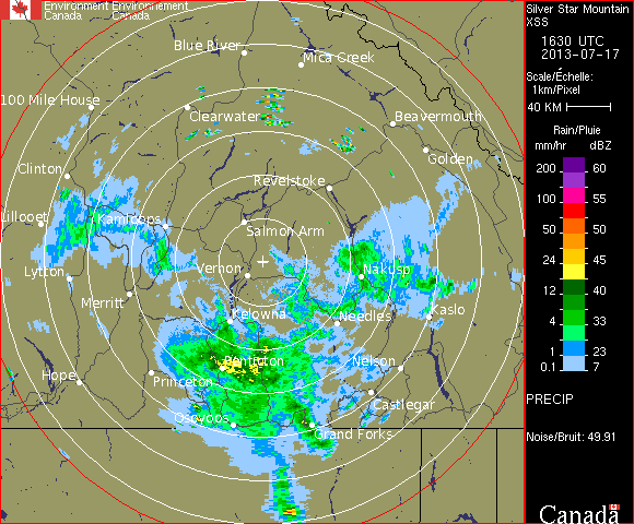
Above: Vernon, BC (Silver Star Mountain) Doppler Station receiving the cloud system that originated in Washington, and driving this system towards the Calgary Doppler Station. The time is July 17, 16:30 UTC.
Above: Strathmore, AB (near Calgary) Doppler station receiving the cloud system from British Columbia (Vernon Doppler Station), that originated from Washington. The timing is July 17, 16:30 UTC (10:30 a.m. MDT).
Above: Calgary's sky, facing north. We see the electromagnetic ripples as signs that a Doppler station has left its mark on these clouds. This is the signature of electromagnetic-induced clouds. All morning photos can be viewed here.
We had just put out an important post detailing how a storm system was generated in north-eastern Montana using the Doppler Station in Glasgow, MT. During that same time, Saskatchewan was also issued tornado warnings by Environment Canada. Saskatchewan Doppler stations have been caught generating two intense storms using electromagnetic energy.
Why is it that time-and-time again, we are finding these suddenly-appearing storm plumes being strangely generated from specific points that precisely align with the centre of Doppler stations? These recent storms appear to be generated from near the centre of Doppler stations and strangely taper towards the centre of the Doppler stations. Our only plausible explanation is the use of electromagnetic waves to control our weather that has been documented in weather modification patents for a long time. The playlist for all related videos can be seen here. Please see the video below:
Video: Storms generated using Radisson & Bethune Doppler Stations in Saskatchewan
The satellite animation for these storms can be seen here and here. Upon watching the Prairie Radar, initially we see quiet activity in the Prairie Doppler stations. Then suddenly, the Doppler Station for Foxwarren (near Brandon) begins pulsing, attracting the tapering storm that was generated by the Glasgow, MT NEXRAD station. This video shows the plume of that same storm generated by the Glasgow Station, which is pushed north-east towards Brandon, MB. We also believe that electromagnetic repulsion may have been assisted by the Minot AFB, ND (KMBX) Station to further push this system north into Brandon, MB. Meanwhile, during this time we see the Doppler Station for Bethune (near Regina) begin pulsing, and then generates a plume-like storm system that is later shown tapering towards the centre of the Bethune Doppler Station. Shortly afterwards, we see the Radisson Doppler Station (near Saskatoon) pulsing electromagnetic waves to create yet another strange storm system, also with its tapering arm oriented towards the centre of the Radisson Doppler Station. During this time, we also see the Edmonton Doppler Station passing its storm system (with accompanying wind) south-east, directly towards Saskatoon.
Above: Satellite Image of the Storms at 1:15 UTC - Pay close attention to the tapering plumes in areas near Glasgow, MT, Foxwarren, MB, Bethune, SK, and Radisson, SK.
Above: In the top-left photo, the red dot represents the location of the Glasgow, MT NEXRAD Station, and the red arrow roughly depicts the general direction of the tapering plume generated in the top-right photo. It is important that the video is watched.
Above: Doppler Image of Foxwarren, MB Station at 1:10 UTC. Note the tapering plume whose tip can be seen passing directly through the centre of the Doppler station. Also take note of the tapering storm arm (S.W.) that appears to be connected to Glasgow, MT.
Above: Doppler Station Bethune (near Regina) at 1:10 UTC. Note the tapering arm to the east that is oriented north east.
Above: Doppler Station Radisson (near Saskatoon) at 1:10 UTC. Also note the tapering arm oriented north-east, generated by this radar station. During this time, the storm system coming from near Edmonton's Doppler Station is being pushed towards this Doppler station.
We also noted multi-networked NEXRAD stations working in unison (Montana, Idaho, Nevada, Utah, etc.) to further feed moisture north-east into Montana and lower Saskatchewan. One can see here, Nevada and Utah NEXRAD station feeding moisture north to Idaho station, which then feeds east to Montana (also see satellite images). We then see the Glasgow, MT station feeding this system north east, into S.E. Saskatchewan. This network of NEXRAD stations is intricate and sophisticated, and we believe there to be a correlation between these interacting stations, and this can be seen on satellite images.
As suggested, we believe these storm systems are generated and driven through the use of electromagnetic methods outlined in numerous weather modification patents described in our recent posts. Furthermore, Environment Canada has removed satellite image frames for North America in between July 15, 21:30 UTC and July 16, 2:45 UTC.
Above / Below: Environment Canada and U.S. Satellites censoring out what may appear to be sprayed aerosols going across Saskatchewan and other areas. We believe this may be the case, as we have seen this type of satellite anomaly related to aerosol spraying and have documented it numerous times.
Above: Very faint remnants of the relevant (networked) NEXRAD-induced weather system can be seen stretching from lower Utah into S.W. Montana, going diagonally north-east into S.E. Saskatchewan. This can further be seen in animation here.
It is interesting to note how these storms in Saskatchewan and the U.S. are lined up north-south almost along the same longitude
Censored out data (top-right) in Arctic regions is quite typical for Environment Canada. One wonders if this censoring has anything to do with what Rosalind Peterson and Dane Wigington have warned the public about, regarding active Geoengineering in northern regions in order to exploit natural resources?
We present a list of important weather modification patents that are responsible for much of the Geoengineering that is taking place today. It is important to glance over this list to become familiar with the methods that were used for modifying our weather, especially the use of aerosols or chemtrails, and transmitter / receiver antenna towers. Much of the technology involving electromagnetism would not be possible without the contributions of Nicola Tesla. Note that many of these inventions are out-of-date and their methods have improved and advanced up until this day. We believe that this type of electromagnetic technology is linked to NEXRAD, and helps to explain how some of these strange tapering storms are generated near the Doppler / NEXRAD stations and driven using electromagnetic waves. More coming soon...
Tornado warnings were issued for Roosevelt, MT yesterday. We see this storm was generated precisely at the NEXRAD Station in Glasgow, MT (KGGW). We can see a tapering plume originate just east of the station, and this is consistent with the satellite image. This is the same storm that entered into Roosevelt County, MT.
We believe that the NEXRAD station is moving this storm system east using electromagnetism, because we can clearly see the wind is moving south. Also, we can see from the NEXRAD radar the ripples which are moving south, yet this storm is generated and made to move east. Please read this developing story here.
Aerosols seen stretching across north-west WA and Okanagan BC, pointing NE towards Edmonton, AB
Prior to an intense Edmonton storm (July 10), our team of Skywatchers have discovered an aerosol plume stretching nearly a thousand miles, across the Pacific and British Columbia. We believe that this was a heavy aerosol-spraying operation. The developing aerosols can be seen here. Closer detail of the aerosol movement can be seen with Intellicast here. A sky time lapse of this aerosol system going over Washington can be seen here and here. What is interesting about this aerosol system is its enormous length and the timing of Doppler / NEXRAD stations becoming very active during this time, further driving in the moisture-collected aerosol clouds to desired areas. Furthermore, these aerosols appear to be related to a weather system that developed near Edmonton and other nearby areas during that time. Take note of how a storm develops at the tip of this aerosol plume extending into Alberta near Edmonton.
During the time which these aerosols were moving across parts of Washington and Oregon, we see very active NEXRAD-pulsing and electromagnetic (EM) activity in Portland, OR, and especially Seattle, WA NEXRAD stations. Interestingly Langley Hill, WA NEXRAD station had its data conveniently missing during this time.
Approximate orientation of the aerosol plume, lining up with active NEXRAD stations (the yellow pins)
These aerosols that stretched across British Columbia conveniently line up with active NEXRAD / Doppler stations, pointing directly towards the Doppler station in Edmonton, AB. In Naramata, BC, we can see the aerosols appearing in the sky (above the cumulus clouds), and the clouds seem to be moving along the same orientation as the plume, while the aerosols actively collect moisture. We believe the aerosols not only to be influenced by NEXRAD / Doppler EM activity, but also gaining help from the wind pattern for July 10.
Aerosol plume collecting moisture, passing through the Pacific region, towards the Kelowna Doppler region, and directed towards Edmonton, AB
In watching where the moisture appears to be travelling, the Doppler stations for the Pacific region can be viewed here. Interestingly, Victoria's Doppler station has missing data during this time in which we see the Prairie Doppler stations (and Edmonton) pulsing intensely. Noting that the data is conveniently missing for the Victoria station (and Langley Hill, WA), during the time which the aerosol plume forms near Victoria, it makes us wonder if moisture is actively being fed from the coast. We see moisture / clouds being fed into Edmonton, AB through the Grand Prairie Doppler station (mostly) and the Kelowna Doppler station. Edmonton Doppler animation can be viewed here. The cloud system coming from Grand Prairie appears to have originated from the Prince George Doppler station that attracted moisture from the east. The cloud system arriving into Edmonton from the Kelowna Doppler station can be viewed here. In that video, we can clearly see moisture / clouds being driven north east directly towards Edmonton, AB.
Edmonton, AB: The high altitude aerosols seen on July 10th seems to be filled with electromagnetic signature prior to the storm
We can see the Edmonton Doppler station appears to be very active during the time which the storm rolls in from the north west, and clouds coming in from the south west. Furthermore, we see the storm heads directly east, and a linear feature can be seen driven south-east. The storm system appears to have been influenced by the Edmonton Doppler station.
The most recent Prairie radar data can be seen here, and during this time (July 10, 22:00 MDT) we see Saskatoon and Regina Doppler stations pulsing intensely, which can also be seen here (July 11, 04:00 MDT). The National Radar for these events can be seen here. After taking a
closer look at the Saskatoon Doppler station, we initially see a quiet radar, and afterwards we see intense electromagnetic activity pick up, which appears to be charging a storm system south east of the Doppler centre. This occurs again later in a similar fashion. The cloud system south east of the radar centre appears to be actively affected by EM waves emitted from the Doppler station. This type of storm generation can also be seen near the Regina Doppler station, which also appears to be super-charging a storm in the south east quadrant during the same time. Afterwards, we see strong EM activity north east of the Doppler station, later sending out energy to the south-west and north-west, while continuing to send out energy towards the north-east.
On the left image, we see moisture lined up to the south east of the radar centre. On the right image, we were able to portray these EM lines going out from the centre of the radar through the linear portions of the storm. Could electromagnetic waves emitted from the centre of the Doppler station explain this strange phenomenon we are seeing?
We must ask ourselves what is causing these mysterious storms to appear around the circumference of the Doppler stations? We also note the wind patterns for Saskatchewan during this time (July 11) is north. Furthermore, we must also take into consideration the weather system moving north-east, originating from the States into Montana and the lower Prairies. Keeping in mind that the wind is moving north, what is causing these storms on the radar to have this lineation oriented towards the centre of the radar if it is not electromagnetically-induced weather?
Edmonton, AB: The wicked storm that was shown advancing on the Doppler radar. The linear features of EM cloud influence seem to correlate well with what we saw on the Doppler radar.
Edmonton, AB: Rotating clouds seen by one resident on July 10th
Edmonton, AB: Storm photographed by a resident and photo-enhanced , showing the strange EM-induced shape
One resident showing the size of hail dropped in some areas of Edmonton, AB
Edmonton, AB: Photograph of strange-shaped hail, appearing to be somewhat flattened
Ootischenia, BC: A last glimpse of the aerosols seen passing through the Kootenay Valley on their way towards Alberta on July 11. Paused at this satellite image, note the fork of aerosols -- one path seen going through the Kootenay Valley, and another path going through the Okanagan Valley.
Windfield, BC: Aerosols seen passing through the Okanagan Valley on July 11th on their way to Alberta
Above: Photos taken by a local resident near Portland, OR, showing these aerosols stretching across the sky on July 11, at 6:45 am (PDT). In the first photo, the left shot is looking towards Mt. Hood (south), and the right shot is facing West. In the second photo, the top shot is again looking towards Mt. Hood (south) and the bottom shot is looking up the Hood River Valley.


+-+1.15.gif)
+-+1.15.gif)


.gif)

.gif)
.gif)

.gif)