Related Articles:
Showing posts with label prairie storms. Show all posts
Showing posts with label prairie storms. Show all posts
Monday, 30 September 2013
Low Pressure System Develops Around Radisson, SK Radar Station
Sept 30/13 - Watch this low pressure weather system develop directly around the centre of the radar circumference at the Radisson, SK Doppler station near Saskatoon.
Related Articles:
Related Articles:
Monday, 22 July 2013
Electromagnetic-Driven Storms & Radar Anomalies for mid-July
What follows is a list of recent activity of storms and radar anomalies seen in parts of Canada and the United States (South Dakota / North Dakota). From the Prairies to Ontario, with neighbouring NEXRAD stations in the United States, we have analysed satellite and radar data to see where these strange tapering storms are coming from. Click on an image to enlarge it for more details.
Below: Toronto, Ontario gets hit with a hard storm, and tornado warnings were issued in the area. Look at where this NEXRAD storm starts and ends. We highly doubt that the media will not mention a word about where this storm precisely originated from in the States.
Below: A photograph captured by a resident of Toronto, showing the city's sky before the storm hit.
Below: If NEXRAD stations could talk, perhaps they could explain to us where all these tapering storms are coming from?
Below: NEXRAD-induced storms: The latest inventions in weather modification using electromagnetism methods listed in patents that aren't new. Ask a meteorologist if it is normal to have these tapering, plume-shaped cloud systems originate from near the centre of these Doppler / NEXRAD stations, being passed from one to another. Are these storms caused by global warming or storms caused by geoengineering. What do you think?
Below: Although he could have done it himself, the Bethune (near Regina) Doppler station would personally like to thank Glasgow, MT and Minot, ND Doppler stations for their minor support in generating this tapered storm system.
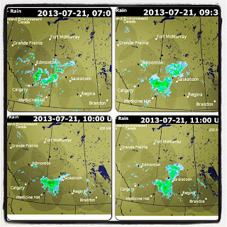
Below: Prairie radar data. This Doppler-driven storm was moving south east in the top two frames, then suddenly at 10:00 UTC in the third frame, data becomes "missing" for the Bethune (Saskatoon) station. After this missing data frame, we suddenly see the storm immediately halt in going south, and it deviates to go directly east. A little strange, wouldn't you say?
Below: These Prairie storms seem to line up and orient themselves so well with the Doppler stations. There is no way electromagnetic forces could influence moisture, or is there?
Below: If storms could talk, what do you think they would say? This one may be using charades to tell us something, as its moisture tapers and points towards the Bethune, SK Doppler station.
Below: Electromagnetic forces can't influence storms, or can they? Read the weather modification patents to find out more. Interestingly, this storm is travelling south east , and we literally see a wave of ripples going south, directly through the centre of the Doppler radar. These cloud ripples appear to hold very little moisture, and are not dense like other parts of the storm system. It almost reminds us of the Doppler waves seen in clouds at times. Is this a signature of the Doppler station being put to use?
Below: North Dakota and South Dakota storms. NEXRAD stations are connecting the dots for us. Can you connect the rest?
Below: Dryden, Woodlands, Winnipeg and other parts of Manitoba would like to thank Canada Doppler stations and North Dakota / South Dakota NEXRAD stations for bringing more storms and rain to their areas. Is geoengineering messing with our water cycle?
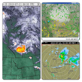
Below: Sit back, relax, and let the Doppler stations connect the dots. The top image shows Prairie radar stations pulsing electromagnetic frequency. The bottom image is Doppler stations connecting the dots for us.
Labels:
Calgary,
Canada,
doppler,
Manitoba,
nexrad,
north dakota storms,
ontario,
prairie storms,
Saskatchewan,
south dakota,
storms,
toronto,
toronto storm,
US storms,
weather,
weather modification,
winnipeg
Thursday, 11 July 2013
Aerosols Nearly 1000 Miles Long & EM-Charged Prairie Storms
 |
| Aerosols seen stretching across north-west WA and Okanagan BC, pointing NE towards Edmonton, AB |
During the time which these aerosols were moving across parts of Washington and Oregon, we see very active NEXRAD-pulsing and electromagnetic (EM) activity in Portland, OR, and especially Seattle, WA NEXRAD stations. Interestingly Langley Hill, WA NEXRAD station had its data conveniently missing during this time.
 |
| Approximate orientation of the aerosol plume, lining up with active NEXRAD stations (the yellow pins) |
These aerosols that stretched across British Columbia conveniently line up with active NEXRAD / Doppler stations, pointing directly towards the Doppler station in Edmonton, AB. In Naramata, BC, we can see the aerosols appearing in the sky (above the cumulus clouds), and the clouds seem to be moving along the same orientation as the plume, while the aerosols actively collect moisture. We believe the aerosols not only to be influenced by NEXRAD / Doppler EM activity, but also gaining help from the wind pattern for July 10.
 |
| Aerosol plume collecting moisture, passing through the Pacific region, towards the Kelowna Doppler region, and directed towards Edmonton, AB |
In watching where the moisture appears to be travelling, the Doppler stations for the Pacific region can be viewed here. Interestingly, Victoria's Doppler station has missing data during this time in which we see the Prairie Doppler stations (and Edmonton) pulsing intensely. Noting that the data is conveniently missing for the Victoria station (and Langley Hill, WA), during the time which the aerosol plume forms near Victoria, it makes us wonder if moisture is actively being fed from the coast. We see moisture / clouds being fed into Edmonton, AB through the Grand Prairie Doppler station (mostly) and the Kelowna Doppler station. Edmonton Doppler animation can be viewed here. The cloud system coming from Grand Prairie appears to have originated from the Prince George Doppler station that attracted moisture from the east. The cloud system arriving into Edmonton from the Kelowna Doppler station can be viewed here. In that video, we can clearly see moisture / clouds being driven north east directly towards Edmonton, AB.
 |
| Edmonton, AB: The high altitude aerosols seen on July 10th seems to be filled with electromagnetic signature prior to the storm |
We can see the Edmonton Doppler station appears to be very active during the time which the storm rolls in from the north west, and clouds coming in from the south west. Furthermore, we see the storm heads directly east, and a linear feature can be seen driven south-east. The storm system appears to have been influenced by the Edmonton Doppler station.
The most recent Prairie radar data can be seen here, and during this time (July 10, 22:00 MDT) we see Saskatoon and Regina Doppler stations pulsing intensely, which can also be seen here (July 11, 04:00 MDT). The National Radar for these events can be seen here. After taking a
closer look at the Saskatoon Doppler station, we initially see a quiet radar, and afterwards we see intense electromagnetic activity pick up, which appears to be charging a storm system south east of the Doppler centre. This occurs again later in a similar fashion. The cloud system south east of the radar centre appears to be actively affected by EM waves emitted from the Doppler station. This type of storm generation can also be seen near the Regina Doppler station, which also appears to be super-charging a storm in the south east quadrant during the same time. Afterwards, we see strong EM activity north east of the Doppler station, later sending out energy to the south-west and north-west, while continuing to send out energy towards the north-east.
closer look at the Saskatoon Doppler station, we initially see a quiet radar, and afterwards we see intense electromagnetic activity pick up, which appears to be charging a storm system south east of the Doppler centre. This occurs again later in a similar fashion. The cloud system south east of the radar centre appears to be actively affected by EM waves emitted from the Doppler station. This type of storm generation can also be seen near the Regina Doppler station, which also appears to be super-charging a storm in the south east quadrant during the same time. Afterwards, we see strong EM activity north east of the Doppler station, later sending out energy to the south-west and north-west, while continuing to send out energy towards the north-east.
We must ask ourselves what is causing these mysterious storms to appear around the circumference of the Doppler stations? We also note the wind patterns for Saskatchewan during this time (July 11) is north. Furthermore, we must also take into consideration the weather system moving north-east, originating from the States into Montana and the lower Prairies. Keeping in mind that the wind is moving north, what is causing these storms on the radar to have this lineation oriented towards the centre of the radar if it is not electromagnetically-induced weather?
 |
| Edmonton, AB: The wicked storm that was shown advancing on the Doppler radar. The linear features of EM cloud influence seem to correlate well with what we saw on the Doppler radar. |
 |
| Edmonton, AB: Rotating clouds seen by one resident on July 10th |
 |
| Edmonton, AB: Storm photographed by a resident and photo-enhanced , showing the strange EM-induced shape |
 |
| One resident showing the size of hail dropped in some areas of Edmonton, AB |
 |
| Edmonton, AB: Photograph of strange-shaped hail, appearing to be somewhat flattened |
 |
| Ootischenia, BC: A last glimpse of the aerosols seen passing through the Kootenay Valley on their way towards Alberta on July 11. Paused at this satellite image, note the fork of aerosols -- one path seen going through the Kootenay Valley, and another path going through the Okanagan Valley. |
 |
| Windfield, BC: Aerosols seen passing through the Okanagan Valley on July 11th on their way to Alberta |
Above: Photos taken by a local resident near Portland, OR, showing these aerosols stretching across the sky on July 11, at 6:45 am (PDT). In the first photo, the left shot is looking towards Mt. Hood (south), and the right shot is facing West. In the second photo, the top shot is again looking towards Mt. Hood (south) and the bottom shot is looking up the Hood River Valley.
Labels:
alberta storm,
BC,
chemtrails,
doppler,
edmonton storm,
electromagnetism,
geoengineering,
kootenay,
nexrad,
okanagan,
portland,
prairie storms,
regina storm,
saskatoon storm,
weather modification
Subscribe to:
Posts (Atom)


