Showing posts with label okanagan. Show all posts

Friday, 21 August 2020

The Reason Why OKANAGAN is BURNING with Forest Fires

It looks like the #BC Lumber industry has a lot of explaining to do ... as #wildfires erupt in and around #logging zones and areas cleared of forest in #Revelstoke and the #Okanagan ... #Kelowna city went as far as even convincing the public that thinning out trees (i.e. further deforestation) would help prevent fires, which is actually just giving them a reason to actively LOG and URBAN DEVELOP those areas. Don't buy this tree thinning lie, because we all know how far wind can carry those lit ashes, which land on dried out timber fallen patches,  covered in  combustible  LOGGING debris.

It's time for the BC government and forestry / logging industry to take accountability for the increased fires that are occurring in our LUMBER driven BC province. They are cutting hundreds of thousands of trees each year, drying out our forests, and leaving patches of combustible timber debris everywhere. They are CREATING the perfect conditions for fire to start. Stop using corporate owned media to conditionally programm people to call it "fire season", when you are actually worsening the fires and making them start. Stop selling our trees to China and the global market in order to fill your own pockets. Stop selling out to the World Bank.


Take a look at the timelapse of the Okanagan above, to see how our land has become transformed, deforested, uprooted, and drought struck over time, bringing us the worst forest fires in our history in the past two decades. ✌🌲🌲🌲🔥🔥🔥


Related Articles:

BC Government & Media LYING about the Cause of Revelstoke FIRES


#OkanaganValley #okanaganfires  #BCfires #Savetheforest #savethetrees #savethepeople #genocide #depopulation #agenda21 #deforestation #canada #SLAVERY #bankers #globalism #globalwarming #climatechange 

Tuesday, 26 May 2015

Vernon Weather Doppler Tower MANIPULATING the Jet Stream

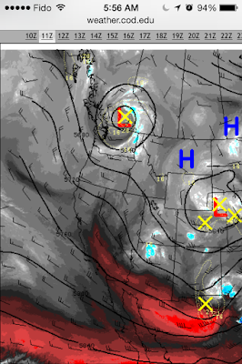
In Central British Columbia, on May, 25, 2015 (around 3:30 - 23:00 UTC), a low pressure system formed directly over Vernon's (Silver Star) Doppler tower. This tower could clearly be seen controlling the jet stream in satellite  and radar animation. This is not the first time this phenomenon has been recorded and it is an ongoing event occurring over other Doppler towers as well. See the related articles below to see more examples.


Look at central British Columbia and the low pressure system that forms over Silver Star Mountain's Doppler tower

Even when viewing the radar animation, one could see the jet stream twirling anti-clockwise around the Doppler site

A 1998 weather patent, entitled, Weather modification by artificial satellites - US 5984239 A states:

A Satellite Weather Modification System (SWMS) uses earth satellites to harness solar energy to modify the thermodynamics and composition of the earth's atmosphere...This technique can also be used to modify the jet stream path and therefore modify the weather on either side of the jet stream.

Now one must ask: if these satellites are capable of doing just that, by using transmitter devices to discharge energy at specific locations, would not Doppler towers equipped with over 700,000 watts (microwave energy) in each pulse be able to alter the atmosphere as well?

Top left: Low pressure system appearing directly over the Doppler tower at Vernon BC's Silver Star Mountain 


A view of the powerful Doppler tower from Silver Star Mountain: The culprit that is affecting our weather and atmosphere

Do not think for a second that controlling the jet stream is out of the realms for mankind:
On September 6, 1987, National Public Radio reported: "Dr. Eastlund stated that his new invention could be used to CHANGE THE WEATHER BY REDIRECTING THE VERY HIGH WIND PATTERNS. ... The invention uses an earth based power source to create electromagnetic radio waves and focus them way up into the atmosphere. Dr. Eastlund says the invention could STEER THE JET STREAM ..."
On the front page of the 1987 patent, there are direct references to the February, 1935 LIBERTY MAGAZINE article about Nikola Tesla; plus references to other Tesla articles in the Dec. 8, 1915 NEW YORK TIMES and Sept. 22, 1940 NEW YORK TIMES:
The 1987 patent states: "...Large regions of the atmosphere could be lifted to an unexpected high altitude... WEATHER MODIFICATION IS POSSIBLE, by for example altering the upper atmosphere wind patterns" (which is exactly what the Russian Woodpecker ELF system does)." ( Source )


Related Articles:


Sunday, 15 September 2013

Weather News and Radar Anomalies for Aug - Sept, 2013

What follows are posts from this page, reflecting recent weather news and radar anomalies from August to September, 2013. We begin with an inspirational post:

During our #prayers, #chants, #reflection, and #mediation, let us not forget the #wisdom of the Emerald Tablets, which #science has only discovered more recently. The #brain #waves of #human #thought and #consciousness can affect #matter and #space in ways unimaginable, just as devices that use #electromagnetic #frequency do. This was proven by numerous #scientists, including #Nikola #Tesla. This phenomenon is also discussed in a film entitled, The Mystery of Water. However, there are some things which physical science will never be able to contain or measure, and it is that which transcends all matter. Should we really underestimate how our #thoughts interact with #matter in the #air? When #indigenous people received #rain and #blessings from #prayers, was it far more than a fiction of the #imagination, or was it perhaps just that...
#Vernon #BC. Aug 10. Heavy #aerosol spraying prior to the predicted #storm. Does the #weatherchannel and #weathernetwork know something that we don't? Perhaps they do if they are getting their information from #Environment #Canada, who actively censor heavy aerosol operations and #EM #weathermodification anomalies on #satellite. What #chemical agents are being used and how do they affect #cumulus #clouds and #storms in general ? Check out the #weather patents describing how #aerosols can be used to strengthen storms.
Learn more about the connection between #airports and #weather control. Many #storms are seen generated near airports and transmitter antennas. This is also spoken about by Dutchsinse.
Aug 12/13. #vernon #bc. Learn more about #cloudseeding #aerosols and how they affect #clouds and #precipitation #weather. The case against #cloud seeding
Aug 13/14, #bc #bcskywatch #okanagan #vernon #Bcweather. Turning the #sky from #blue to #white . Expect a #temperature drop. The #weather patent deals with the spraying of #aluminum #aerosols used for #geoengineering .
Aug 14. From #clearskies to #metallic #aerosols covering the #sky. #Vernon #BC #okanagan . Also note that the silver star #Doppler has missing data 1.20 - 4.00 PDT. #satellite animation and #radar show smaller #clouds forming with #aerosols and #moisture in a #doppler like fashion, suggesting #electromagnetic influence.
Looks like #Vernon #BC folks need a letter warning them of the metallic particulates and chemical agents being sprayed into their skies in the name of #geoengineering -- perhaps something similar to the #Penticton scare letters received by #Okanagan residents, this time detailing the exact #weather patents and undeniable evidence that will stir up and cause a social reform to end this madness.
Aug 15. With #Okanagan #Vernon #Kelowna #BC #skies laced with metallic #aerosols from days prior, it looks like #NEXRAD in #Washington coast and #Doppler stations in lower #BC are driving in #clouds from the coast. We noted how the NEXRAD animations showed #moisture being driven through the centre of the #Doppler , and #satellite showing the #weather system heading north into BC.
Aug 16/13. With #weather forecasters relying on #environment #Canada and their data, it looks like lower #BC and #Prairies (#Alberta) are in for some rain. This is being achieved using the tropospheric rivers, using #aerosols to draw in moisture, and #NEXRAD electromagnetism . They want to control #mother #nature at the expense of #environmental damage, instead of letting her be. 
Aug 16/13. Connecting the dots, literally -- #weather system stretching north east from #oregon and #washington into lower #BC and #Alberta. This system is made to move north using #electromagnetism techniques. The #weathernetwork and #weatherchannel fail to report these anomalies, as they simply regurgitate tele-scripts and #Environment Canada's selective data. We can clearly see #NEXRAD stations connecting #clouds and moisture using the tropospheric river, diverting moisture away from #Idaho. Perhaps the fires in Idaho are the result of moisture and clouds being diverted elsewhere using this #weather patent technology? With active metallic #aerosol spraying and NEXRAD #electromagnetism use for #geoengineering, we let the #radar and #satellite speak for themselves...
Aug 17/13 - When your sunlight becomes blocked by sprayed and dispersed toxic #aerosol that lingers in the #sky -- #okanagansky in #Vernon #BC #vernonsky #kelownasky #chemtrails #bcchemtrails #bcskywatch #okanaganskywatch
Aug 18 & 19/2013 - Satellite shows us a significant line of "clouds" (aerosols) being shaped by #Doppler stations. Doppler stations are the black dots. We see the edge of these #aerosols being shaped by #electromagnetic activity emitted from #PrinceGeorge and #SilverStar radar in central #BC. The line of aerosol clouds actually line up diagonally, connecting the Doppler dots for us. The aerosols rob moisture from the air, creating a large mat of blanketed clouds, instead of the naturally-forming #cumulus #clouds with #sunny peaks. Doppler stations in #Vancouver and #Victoria are also involved, and their radars overlap for this very reason.
#NEXRAD / #Doppler connected moisture, from #california, to #oregon, to #washington , to #BC and #Alberta. It seems like man never learns his lesson. Instead of helping drought conditions, they keep spraying #metallic aerosols used for #climate engineering, which rob moisture from the air and pollute soil and plants. Again, diverting #rain and moisture from one area to another, perhaps to put out fires in OR and WA? But again, is that not depleting one area for another, causing more droughts? It's like a never ending cycle. Let #motherNature do her job and send her own rain, because she does it way better than man, who uses #science that always ends up benefitting something at the expense of another.
Aug 26/13 - Tracking southern #Alberta #Calgary #storm from last night, that brought some intense #lightning . After viewing the radar, we can see that these storms were ignited from #NEXRAD stations in #idaho , #Montana , and #Washington . It appears that the storms were fed moisture off a much larger #geoengineered system stretching down to #California. Nevertheless, these storms were driven using #electromagnetism , steering the storms north on an unnatural course into #Alberta.
Aug 26/13 - Perhaps the #rain and #moisture from the #drought stricken Western states are being fed elsewhere. We can clearly see a #storm being fed and ignited in #Wisconsin precisely at the #NEXRAD station. These generated storms, whose moisture are connected and driven through the vast network of radar / Doppler stations, made their way into southern #Ontario #Toronto. Of course, the regurgitated #weather news and information from #Environment #Canada will never show us such anomalies. The #electromagnetic weather patents have been around for quite some time now, regarding the charging and steering of storm systems. Perhaps this is why we see so many storms being generated near the #Doppler / #NEXRAD facility, with moisture tapering directly towards the centre of the Doppler?
#NEXRAD / #Doppler facilities using #electromagnetism to divert #moisture north from southern #california , diagonally into the north central #states. We can clearly see NEXRAD-connected moisture. South Cali residents--don't be surprised if you are getting bad #droughts #sandiego
#arizona #nexrad devices caught stealing moisture from #Mexico , and driving it north into #Utah using #electromagnetism . The more they play with #mothernature , the worse the consequences will be.
#NEXRAD , you wouldn't happen to be influencing #storms in the #States and southern #Alberta , now would you? Perhapos climate engineering has its limits, as with all sciences, and perhaps this moisture diversion and storm enhancement affecting Canada is an indirect result of what occurs in the States--after all, we are all connected right ?
"Captain! There is an intense NEXRAD storm ahead, should we turn around?" "No!" [Announcement] "Dear Passengers, we will be passing through a stormy area. Please remain calm, go back to your seats and fasten your seat belts. Expect severe turbulence for 20 minutes. Thank you for your cooperation" "Phew!"

#NEXRAD #storm control in #Michigan #US . #electromagnetic #doppler influence . Why do we see the moisture in these storms tapering towards active Doppler / NEXRAD stations, and mimicking their radar circumference ?
Aug 29/13 - Intense storms and #lightning hit the #Prairies, with some #flooding occurring in Edmonton, #AB -- #NEXRAD charged #storms are ignited and fed north into southern #Alberta and the #Prairies using #electromagnetism. The main #Doppler station of interest is in #GreatFalls #MT . We clearly see the storms being driven from #Montana on an unnatural course north into Alberta. The first frame is satellite image showing #cloud cover using infrared radar. The second is showing heavy #electromagnetic pulsing at the #Missoula #MT NEXRAD station. The third frame is the storm being generated at the Great Falls, MT NEXRAD station. The fourth frame is the #Calgary #radar station, showing a "hole punch" anomaly at the centre of the #strathmore #doppler prior to the approaching storm. We noted that the frames from 1:00 to 7:00 MDT have either been removed or are conveniently missing. The last two frames show the storms being pushed directly through the centre of #Strathmore and #Carvel (#Edmonton) #Doppler #radar .
Sept 5 - 2013 - North #Okanagan and #Vancouver area in southern #BC get slammed by a #NEXRAD / #Doppler charged #storm, causing #power outages for thousands of residents. Some Vancouver residents described it as the worst storm they have ever witnessed in their area. #Environment #Canada had the courtesy to admit that this was a low pressure system that pushed up north from #Washington. However, what they failed to mention was the numerous #Doppler signatures that appeared throughout this storm. The first image shows moisture in the developing storm tapering towards the Vancouver Doppler station, appearing to be passed to the #Kelowna station using #electromagnetic waves. The #Victoria Doppler station had its data conveniently missing during this time. In the second frame (right), we see the bulk of moisture in the storm coming from Washington to pass directly through #Vernon (Kelowna) Doppler centre. Note the severe red area being charged near the centre. The third image shows a close up of Vancouver Doppler, again showing moisture tapering towards the centre. The fourth image shows the #Seattle #NEXRAD / #doppler station actively charging the storm, with its tapering moisture seen again. We also noted Langley Hill, #WA #NEXRAD station having large chunks of data "missing" , as seen with the coastal Victoria Doppler station. The fifth image shows the storm further being fed from #Spokane, WA #doppler station. The lines of moisture sweep directly through the centre and head north into BC. The last frame shows these lines of moisture originating near #Pendleton, #Oregon #Doppler station. Let us not forget the enormous amount #electricity these Doppler stations consume, and their relation to the #weather patents that speak about the charging and controlling of storms and lightning.
Sept 8th - 0:00 MDT - Ask a meteorologist this: why are clouds and moisture circling our radar / Doppler circumference ? How do water / clouds react to electromagnetic microwaves (over 700,000 watts) pulsed at certain frequencies coming from these active Doppler / NEXRAD radar sites? We show Montana's Billings (KBLX) site as merely one example...
Sept 8/13 - 0:00 MDT - Having #moisture trailing from #Hawaii to #Mexico, up through North #America, this storm shows how well-connected it is to actively pulsing #NEXRAD radar sites. It is being controlled from all sides, its moisture being fed through the vast chain of NEXRAD sites stretching all the way down to Mexico. Mexico is probably still wondering why their northern #droughts are worsening. The fourth frame showing #Bismark, #ND NEXRAD site is a good example of how one end of this artificially-charged #storm is situated right around the #radar centre, where the large #transmitter #antenna sits, emitting more than 700,000 #watts of #microwave #energy into the #sky with each pulse. 
September 9/13 - It appears as though #NEXRAD stations and other #electromagnetic #weather patented technology (including chemical aerosols) are working in unison to #climate engineer a massive #weather front. This huge weather front can be seen originating in the #Gulf of #Mexico, its moisture being driven up through Mexico, into the #US (through #Arizona and #Texas), stretching up into the #Canadian #Prairies. What is interesting is that we find #moisture being channelled through active #NEXRAD sites, all the way from #Arizona to #Montana and #North #Dakota. We also see moisture at active NEXRAD radar sites, sometimes conforming to the radar circumference in some instances.
Sept 14/13 - Keep in mind the strong electromagnetic (microwave) activity at each NEXRAD site, which consumes large amounts of energy. Moisture is travelling south west from Glasgow, MT NEXRAD station to Billings, MT station, showing both in radar and satellite the moisture adhering to the radar centre. In the Dakotas, we have moisture travelling east. Bismark, ND NEXRAD station clearly shows moisture passing right through its radar centre. In Aberdeen, SD NEXRAD site, we see moisture adhering to the radar circumference, forming a rounded storm. These radar anomalies occur far too often to be coincidences.
Sept 14/13 - Check out our recent posts on moisture being diverted from Arizona and New Mexico. Well it looks like much of this rain has also fallen in New Mexico, causing flooding--specifically in Albuquerque, NM, exactly where the NEXRAD radar site is situated. Coincidence?
Sept 14/13 - #Flooding in #Colorado seems to be linked to the "cloud plumes" that originated from below New #Mexico and #Arizona, near active #NEXRAD sites. We also noted the "pencil beams" that were emitted from the transmitter antennas at the radar sites in Arizona. The dots connect even more when you read our recent posts on moisture diversion with active #NEXRAD sites that has been occurring throughout New Mexico and Arizona during the past weeks. Should we suppose that the best way to put out a drought is by dumping loads of rain to cause flooding, when perhaps we wouldn't have this problem in the first place if we let the natural cycle run its course without man diverting moisture and weather patterns? Let us not also forget the amount of evapotranspiration and locked-in moisture that plants and trees provide before they are cut down for farmland, cattle, development, etc. Is this really sustainable development, when we lose the real sustenance ?

Thursday, 11 July 2013

Aerosols Nearly 1000 Miles Long & EM-Charged Prairie Storms


Aerosols seen stretching across north-west WA and Okanagan BC,
pointing NE towards Edmonton, AB
Prior to an intense Edmonton storm (July 10), our team of Skywatchers have discovered an aerosol plume stretching nearly a thousand miles, across the Pacific and British Columbia. We believe that this was a heavy aerosol-spraying operation. The developing aerosols can be seen here. Closer detail of the aerosol movement can be seen with Intellicast here. A sky time lapse of this aerosol system going over Washington can be seen here and here. What is interesting about this aerosol system is its enormous length and the timing of Doppler / NEXRAD stations becoming very active during this time, further driving in the moisture-collected aerosol clouds to desired areas. Furthermore, these aerosols appear to be related to a weather system that developed near Edmonton and other nearby areas during that time. Take note of how a storm develops at the tip of this aerosol plume extending into Alberta near Edmonton.

During the time which these aerosols were moving across parts of Washington and Oregon, we see very active NEXRAD-pulsing and electromagnetic (EM) activity in Portland, OR, and especially Seattle, WA NEXRAD stations. Interestingly Langley Hill, WA NEXRAD station had its data conveniently missing during this time. 

Approximate orientation of the aerosol plume, lining up with 
active NEXRAD stations (the yellow pins)
These aerosols that stretched across British Columbia conveniently line up with active NEXRAD / Doppler stations, pointing directly towards the Doppler station in Edmonton, AB. In Naramata, BC, we can see the aerosols appearing in the sky (above the cumulus clouds), and the clouds seem to be moving along the same orientation as the plume, while the aerosols actively collect moisture. We believe the aerosols not only to be influenced by NEXRAD / Doppler EM activity, but also gaining help from the wind pattern for July 10.

Aerosol plume collecting moisture, passing through the Pacific region,
towards the Kelowna Doppler region, and directed
towards Edmonton, AB
In watching where the moisture appears to be travelling, the Doppler stations for the Pacific region can be viewed here. Interestingly, Victoria's Doppler station has missing data during this time in which we see the Prairie Doppler stations (and Edmonton) pulsing intensely. Noting that the data is conveniently missing for the Victoria station (and Langley Hill, WA), during the time which the aerosol plume forms near Victoria, it makes us wonder if moisture is actively being fed from the coast. We see moisture / clouds being fed into Edmonton, AB through the Grand Prairie Doppler station (mostly) and the Kelowna Doppler station. Edmonton Doppler animation can be viewed here. The cloud system coming from Grand Prairie appears to have originated from the Prince George Doppler station that attracted moisture from the east. The cloud system arriving into Edmonton from the Kelowna Doppler station can be viewed here. In that video, we can clearly see moisture / clouds being driven north east directly towards Edmonton, AB. 

Edmonton, AB: The high altitude aerosols seen on July 10th seems to be
filled with electromagnetic signature prior to the storm
We can see the Edmonton Doppler station appears to be very active during the time which the storm rolls in from the north west, and clouds coming in from the south west. Furthermore, we see the storm heads directly east, and a linear feature can be seen driven south-east. The storm system appears to have been influenced by the Edmonton Doppler station. 

The most recent Prairie radar data can be seen here, and during this time (July 10, 22:00 MDT) we see Saskatoon and Regina Doppler stations pulsing intensely, which can also be seen here (July 11, 04:00 MDT). The National Radar for these events can be seen here. After taking a
closer look at the Saskatoon Doppler station, we initially see a quiet radar, and afterwards we see intense electromagnetic activity pick up, which appears to be charging a storm system south east of the Doppler centre. This occurs again later in a similar fashion. The cloud system south east of the radar centre appears to be actively affected by EM waves emitted from the Doppler station. This type of storm generation can also be seen near the Regina Doppler station, which also appears to be super-charging a storm in the south east quadrant during the same time. Afterwards, we see strong EM activity north east of the Doppler station, later sending out energy to the south-west and north-west, while continuing to send out energy towards the north-east. 

On the left image, we see moisture lined up to the south east of the radar centre. On the right image, we were able to portray these EM lines going out from the centre of the radar through the linear portions of the storm. Could electromagnetic waves emitted from the centre of the Doppler station explain this strange phenomenon we are seeing?


We must ask ourselves what is causing these mysterious storms to appear around the circumference of the Doppler stations? We also note the wind patterns for Saskatchewan during this time (July 11) is north. Furthermore, we must also take into consideration the weather system moving north-east, originating from the States into Montana and the lower Prairies. Keeping in mind that the wind is moving north, what is causing these storms on the radar to have this lineation oriented towards the centre of the radar if it is not electromagnetically-induced weather?

Edmonton, AB: The wicked storm that was shown advancing on the Doppler radar. The linear features of
EM cloud influence seem to correlate well with what we saw on the Doppler radar.
Edmonton, AB: Rotating clouds seen by one resident on July 10th
Edmonton, AB: Storm photographed by a resident and photo-enhanced ,
showing the strange EM-induced shape
One resident showing the size of hail dropped in some areas of Edmonton, AB
Edmonton, AB: Photograph of strange-shaped hail, appearing to be somewhat flattened
Ootischenia, BC: A last glimpse of the aerosols seen passing through the
Kootenay Valley on their way towards Alberta on July 11. Paused at this satellite image, note the fork of
aerosols -- one  path seen going through the Kootenay Valley, and another path going through the Okanagan Valley.
Windfield, BC: Aerosols seen passing through the Okanagan Valley on July 11th on their way to Alberta

Above: Photos taken by a local resident near Portland, OR, showing these aerosols stretching across the sky on July 11, at 6:45 am (PDT). In the first photo, the left shot is looking towards Mt. Hood (south), and the right shot is facing West. In the second photo, the top shot is again looking towards Mt. Hood (south) and the bottom shot is looking up the Hood River Valley.