Showing posts with label toronto storm. Show all posts

Monday, 22 July 2013

Electromagnetic-Driven Storms & Radar Anomalies for mid-July

What follows is a list of recent activity of storms and radar anomalies seen in parts of Canada and the United States (South Dakota / North Dakota). From the Prairies to Ontario, with neighbouring NEXRAD stations in the United States, we have analysed satellite and radar data to see where these strange tapering storms are coming from. Click on an image to enlarge it for more details. 


Below: Toronto, Ontario gets hit with a hard storm, and tornado warnings were issued in the area. Look at where this NEXRAD storm starts and ends. We highly doubt that the media will not mention a word about where this storm precisely originated from in the States.


Below: A photograph captured by a resident of Toronto, showing the city's sky before the storm hit.


Below: If  NEXRAD stations could talk, perhaps they could explain to us where all these tapering storms are coming from?


Below: NEXRAD-induced storms: The latest inventions in weather modification using electromagnetism methods listed in patents that aren't new. Ask a meteorologist if it is normal to have these tapering, plume-shaped cloud systems originate from near the centre of these Doppler / NEXRAD stations, being passed from one to another. Are these storms caused by  global warming or storms caused by geoengineering. What do you think?


Below: Although he could have done it himself, the Bethune (near Regina) Doppler station would personally like to thank Glasgow, MT and Minot, ND Doppler stations for their minor support in generating this tapered storm system.


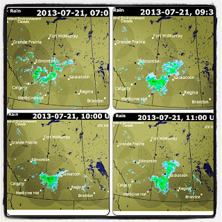
Below: Prairie radar data. This Doppler-driven storm was moving south east in the top two frames, then suddenly at 10:00 UTC in the third frame, data becomes "missing" for the Bethune (Saskatoon) station. After this missing data frame, we suddenly see the storm immediately halt in going south, and it deviates to go directly east. A little strange, wouldn't you say?


Below: These Prairie storms seem to line up and orient themselves so well with the Doppler stations. There is no way electromagnetic forces could influence moisture, or is there?


Below: If storms could talk, what do you think they would say? This one may be using charades to tell us something, as its moisture tapers and points towards the Bethune, SK Doppler station.


Below: Electromagnetic forces can't influence storms, or can they? Read the weather modification patents to find out more. Interestingly, this storm is travelling south east , and we literally see a wave of ripples going south, directly through the centre of the Doppler radar. These cloud ripples appear to hold very little moisture, and are not dense like other parts of the storm system. It almost reminds us of the Doppler waves seen in clouds at times. Is this a signature of the Doppler station being put to use?


Below: North Dakota and South Dakota storms. NEXRAD stations are connecting the dots for us. Can you connect the rest?


Below: Dryden, Woodlands, Winnipeg and other parts of Manitoba would like to thank Canada Doppler stations and North Dakota / South Dakota NEXRAD stations for bringing more storms and rain to their areas. Is geoengineering messing with our water cycle?


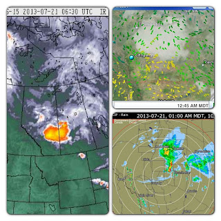
Below: Sit back, relax, and let the Doppler stations connect the dots. The top image shows Prairie radar stations pulsing electromagnetic frequency. The bottom image is Doppler stations connecting the dots for us.


Wednesday, 10 July 2013

Toronto Flooding - Electromagnetic-induced Weather System & Censored Data

The media is describing the recent Toronto storm as an unexpected sudden and violent thunderstorm:

"What occurred over a few short hours last night was unprecedented," Ford told reporters at a news briefing, referring to the 126 millimetres of rain that fell on the city in just two hours last night. The downpour was more than the amount of precipitation Toronto would get in an average July. The torrential rain and squalls downed trees, flooded subway stations and basements, and stranded motorists in murky waters ... David Phillips, a climatologist with Environment Canada, said those rains may have been "the most intense, wettest moment in Toronto's history."

Here is satellite animation for Eastern Canada, July 7 - July 10. The Doppler animation for the Ontario region can be viewed here. Watch the large storm system develop, that flooded areas in and around Toronto, ON. You will notice that these storm systems extend into the northern States, as was seen prior to the Alberta flooding. We already know NEXRAD devices were behind modifying storm systems prior to the Alberta flood -- now the question lies as to what exactly occurred around Toronto? The Weather Network has omitted mentioning that the heavy storm system was linked to the U.S. and that it also came from the northern States, and portrays the "flood storm" as an isolated system.

Toronto seemed fine prior to the electromagnetic beams being emitted from this Doppler station at various times. In this looped video, pay close attention to below the centre of the Doppler station. You can see the small clouds moving from the bottom up, being aligned and attracted to the centre of the Doppler station, just as metallic filaments would line up near the EM field of a magnet. We believe this station was pulsing electromagnetic waves to further attract the north-east-bound oncoming storm. In the beginning of the detailed version of the Toronto Doppler animation, we see a cloud being attracted by the means of EM frequency directly through the centre of the Doppler station. During and after this time, we see strong electromagnetic attraction causing the cloud system to grow as it attracts and binds other water molecules in close proximity. The linear features in this cloud system and other electromagnetic signatures can be seen throughout the animation. Some clouds will even mimic the circumference of the radar. Unfortunately, we do not have NEXRAD data from the U.S. Stations near Toronto, as was shown in the case for Calgary, AB, except for this one in Buffalo, NY. This NEXRAD station also appears to be very active, and it appears that the storm system is responding to electromagnetic waves emitted from this station as well.

Toronto seemed fine prior to the electromagnetic beams being pulsed from this Doppler station. In the top left frame, we see an electromagnetic beam being pulsed north-west. In the top right frame, we see the storm system being pushed north east into Ontario from the States, which was not mentioned by the weather media. In the bottom right frame, we see this north-west pulsing again; and thereafter, we the second storm originating from the north-west. We all know that water particles, especially when laced with metallic aerosols, respond to electromagnetic waves. Coincidence?
Environment Canada continues to censor crucial weather data to help in understanding the development of this storm system. We have noted that these frames for the satellite IR data have been removed / censored by Environment Canada:

July 8 - 4.45 - 5.15 EDT (CENSORED All Regions)
July 8 - 12.15 - 14.45 EDT (Missing Frames)
July 9 - 21.15 EDT (Censored South)
July 10 - 10:45 - 11:15 EDT (CENSORED All Regions)

Please see this video made by one user. Here is an interesting comment left by one individual with emphasis added:

These circles you refer to are [electromagnetic] frequencies created by NEXRAD. They [can] act as ionic heaters. Dutchsinse, Weather101, and Jim Lee have the best independent information available in understandable language. These extreme storms have been occurring in the U.S. for years, along with manipulated frequency injections that create them. NEXRAD and perhaps other directed-energy [devices], along with chemicals, stratospheric-aerosol geoengineering [can alter our weather] ... none of this is natural.

Here is another interesting video depicting a roll cloud that was seen extending across Toronto, similar to what was seen during the Calgary flooding.