For the first time ever, we are now able to see how the nation's weather develops near active NEXRAD sites. In the video. each dot representations a NEXRAD Doppler site, capable of emitting over 700,000 watts of microwave energy in each pulse. We can clearly see developing weather systems being affected in areas within close proximity to these NEXRAD sites. With large receiver and transmitter capacity, these devices can act like local HAARP stations. Weather patents and research for climate engineering supports this theory (see below).
We believe that these devices are using electromagnetic forces to actively alter moisture flux divergence patterns, synoptic fronts, upper air surroundings, the jet stream, and other naturally-occurring weather patterns. This may also be further achieved through the deployment of metallic aerosols sprayed with jets, and power plant aerosol emissions creating excessive moisture from the ground.
The second NEXRAD map used (with red dots) is nearly accurate, with the exception of some of the far north eastern states. We tried our best to overlay the map accurately within another layer:
To learn more about how power plant aerosols affect our weather, see this video below:
When watching the video below, keep in mind some of the weather patents related to ice-nucleation and other Geoengineering operations. Patent US5360162 A, published in 1994:
A method for precipitating atmospheric water by means of multicomponent aerosols, including iodide based complex multicomponent aerosol compositions. The compositions comprise a solid mass formed by a compacted mixture of silver iodide and the iodides, iodates, and periodates of alkali metals, lead, copper, BARIUM ; AMMONIA, barium chromate, and selected oxidizers such as ammonium perchlorate, and fuels such as poly-p-phenylene, phenol formaldehyde resin, epoxide resin, and shellac and mixtures thereof. The compositions, upon burning, produce an aerosol effective to promote atmospheric water precipitation. (US Patent: http://www.google.ca/patents/US5360162 , Canada Patent: http://brevets-patents.ic.gc.ca/opic cipo/cpd/eng/patent/2069138/summary.html )
This leaves us some questions: What are the health and environmental effects of spraying such chemicals into our air? Should we not be opposing such actions, and lobbying our government? Why does Environment Canada keep on insisting that the lingering persistent contrails (white streaks) seen behind certain high-altitude jets are simply the product of water vapour? Should we not be testing for the presence of such chemicals in our rain and snow? The only way to determine the presence of chemical aerosol agents is to test such samples of snow / rain in a lab. By reading the weather patents, we can determine what it is that we are searching for.
Where are barium compounds being purchased before they are disbursed into our air?
Around the time of 23:00 UTC (Nov 12/13), pencil beams of directed energy were sent out of NEXRAD sites throughout the central-eastern States. Immediately after this time, on satellite imagery, we see a vast artificial cloud cover being generated over those areas. We believe these may be ionized clouds resulting from the directed energy of pencil beams emitted from the NEXRAD sites working in unison. See the full playlist of events here.
Often times climate-engineering aerosols are sprayed in a certain fashion in order to influence the jet stream or connect storm systems. Why is the local weather media not showing us the "whole"picture with regards to Storm Sonia and its moisture being channelled by Doppler sites into the States and Canada?
Above is a rough timeline of the life cycle of Storm Sonia that devastated parts of Mexico with severe flooding. Was it climate engineered? Were aerosol dumps used to manufacture this storm? Was satellite or land-based electromagnetic energy used to intensify the storm cell? This we can only speculate. What we are certain of is that this storm was stationary for over 12 hours, growing intensely, and finally began moving towards the coast. It dropped a load of rain on northern Mexico, while its moisture was also being channelled and brought into the States via the NEXRAD network. The question remains: how much of this moisture fell on Mexico and how much of it was transferred into the States? Did any SkyWatchers notice chemical aerosols being sprayed in their skies along this trail of well-connected moisture prior to or during Storm Sonia?
A playlist for various satellite views of the developing Storm Sonia can be viewed here.
Moisture was being electromagnetically-driven through Texas' NEXRAD sites into the States through the active Doppler network. This can be seen in photos here. Furthermore, an enormous roll cloud was spotted in Texas on Nov 3/13, like the one that formed over Washington's NEXRAD site months ago. The roll cloud was seen stretching across Canyon, TX, and formed near Amarillo, TX NEXRAD station (KAMA). Could this all be linked?
Storm Sonia flooding Mexico? Moisture being electromagnetically-driven through Texas' NEXRAD sites into the States through the active Doppler network? An enormous roll cloud spotted in Texas, like the one that formed over Washington's NEXRAD site months ago? Heavy aerosol spraying by climate engineers in the western states (eg. California and Nevada)? Could this all be linked?
It appears that the moisture from Storm Sonia has been driven up through Texas into the eastern states, now making a sharp boomerang turn towards California. From the satellite, it appears that climate engineers are trying to make this a well-connected weather front, as the western states may soon be connected to this vast storm system. The video for the Texas roll cloud can be viewed here.
Nov 4/13 - Moisture from Mexico's storm Sonia is being driven into the U.S. via the NEXRAD network, starting with Texas. One question remains however: did Storm Sonia develop by herself, or was she assisted and climate-engineered off the Pacific coast (i.e. near Hawaii) using aerosols that are commonly deployed in those areas?
The pictures below show the sequence of storm development, and how the clouds are driven into the States through Texas' NEXRAD sites. Also note NEXRAD stations in the Eastern states pulsing to either attract or repel clouds / moisture.
Oct 27/13 - The snow forecast came true, after heavy aerosol-spraying days prior, when the paid climate engineers were preparing the way for this jet stream. Now we can see this moisture-collected weather front being further directed/shaped by electromagnetic forces at active Doppler sites, where moisture is being fed from NEXRAD sites near the coast. Take a look at the tapering plume-shaped clouds coming out of the region at Portland, OR NEXRAD site. Also notice the aerosol trails that are being sprayed in the Pacific ocean, which is further feeding this weather front.
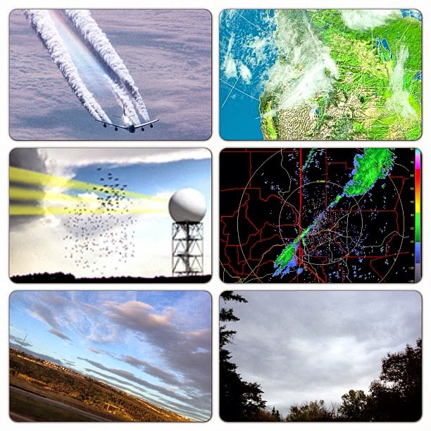
Provided below are images for recent radar anomalies and weather news reports during September and early October, 2013. All images and posts are taken from this page.
Are transmitter / receiver devices influencing our weather? Intellicast seems to suggest this, as we can see a region of #rain / moisture hovering over a large area where the Globalstar Gateway devices are located. This is West of #HighRiver, #Alberta.
Sept 18/13 - Can you match together the pieces of the radar puzzle on the satellite image? Clearly we can see a correlation between the shaping of our weather systems and radar circumference, can we not?
Sept 18/13 - If you could see clouds forming around the NEXRAD radar circumference as seen with these satellite and radar images, what could you infer? How do water molecules in the air react to electromagnetic forces emitted from these radar stations ? Has this phenomenon been studied yet by scientists, or is it over-looked and forgotten?
A roll cloud generated with the help of electromagnetic forces. Must we say anymore? Check out Dutchsinse on Facebook, YouTube, or Google his website.
Sept 21/13 - Watch what appears to be a cloud roll driven directly through the centre of the Spokane, WA (NEXRAD) meteorological station. These moisture-containing clouds align perfectly with the centre of the radar circumference. Is NEXRAD doing rails?
Sept 21/13 - how to leave the pulsed aerosol skies behind. Open up Intellicast. Find the "sky pockets" near your area and note the wind orientation. Travel in that direction towards clear skies. Enjoy the sunshine. The red arrow shows the direction (West) we travelled to reach the sunny side, and the last picture shows us looking back East to see the white mass of aerosol-covered skies where we formerly were.
Sept 22/13 - Another #tornado over the Kirtland Air Force Base in #Albuquerque, #NewMexico. Coincidence? Check out Dutchsinse on Facebook
Sept 24/13 - Climate Engineering in a nutshell: Spray metallic aerosols inland and over ocean while a tropospheric river is advancing towards land. These metallic particles rob water vapour from the air to form "clouds", thus diminishing cumulus clouds' to form. These metallic-laced clouds can then be shaped and directed with electromagnetic wave frequency i.e.NEXRAD radar stations, like the one shown centred in the 4th frame. With all NEXRAD / Doppler devices working in unison, an enormous "cloud front" can be created. Many of today's weather patents were designed for military industrialization and so-called "defence" purposes, regarding satellite communications, weaponized weather, and much more.
Sept 28/13 - Covering vast parts of the #sky and blocking our #natural #sunlight as this aerosol-laced #weather front moves in from the West. Clearly, spraying planes were seen in #Alberta and Western states (#Nevada, #Washington, #Oregon, etc). #Calgary #skies were filled with #doppler signatures of #electromagnetic #frequency left in the #metallic-laced #clouds. May #Creator destroy the #sky perverters and restore our #weather in due time.
Sept 27-28/13 - #NEXRAD-active regions bringing in metallic #aerosol-laced #weather fronts where they don't belong. Also known as "#cloud forcing", this is depleting one area of #moisture for another. Perhaps what we experience as "global #warming" bizarre weather patterns is a direct or indirect result of tampering with #Mother #Nature using weather-patented #aerosols and #electromagnetic frequency, such as #HAARP, #ionization, transmitter antennas (Doppler), cellphone towers, HV power lines that create corona ions and affect our weather in ways that have yet to be more closely studied. The massive weather front seen in satellite image was reported as being half the size of #US
Sept 28/13 - Could this be a trail of aerosols left behind an advancing weather front, stretching nearly the size of half the U.S. in length?
Sept 28/13 - Sometimes, a picture says a thousand words...
Sept 29/13 - Ask a meteorologist this: why is the heaviest amount of precipitation occurring around these active NEXRAD stations ?
Sept 29/13 - As a tropospheric front approaches from the West coast, we can see NEXRAD Doppler (radar) leaving its marks in the clouds. It's not rocket science however--something that is emitting up to 700,000 watts of microwaves acting upon matter (sky & clouds), will those particles of matter not respond and be affected ? Welcome to NEXRAD weather manipulation
Sept 29/13 - Why do moisture / clouds, or perhaps metallic aerosol-laced clouds seen to be passing directly through the centre of Eureka, CA NEXRAD (Doppler) radar, leaving behind "doppler" signatures in the clouds?
Sept 30/13 - Watch this low pressure weather system develop directly around the centre of the radar circumference at the Radisson, SK Doppler station.
Oct 2/13 - Check out the tapering linear weather front making its way into California, Nevada, and Idaho. The radar doesn't show this "cloud" formation as containing any moisture (ie. Nevada), and the tapering cloud simply does not show up on the radar. With supporting photographs from SkyWatchers in Cali, Nevada, etc. should we presume that these "clouds" appearing on satellite are simply sprayed chemical agents that haven't collected any moisture as of yet.
Oct 5/13 - Usually after the atmosphere is sprayed with metallic particles, one can see signs of an electromagnetic-carved sky. As this weather front approaches from the West, we can see it being pulsed by Doppler and other EM waves, as it comes in "waves". You may notice the faint circles in some areas where the Doppler sites are located. More importantly, take note of the Rockies region being clear, as this is where the Doppler's electromagnetic signal begins to diminish from both AB and BC side.
Oct 6/13, 5.00 UTC - Take a look at this weather front in the Eastern states, and see where the moisture is precisely being channeled and driven. In each radar image, there lies a powerful Doppler facility at the centre.
Oct 6/13 - What was described by the media as an unusually strong storm, brought hail and rain to South Dakota, generating 9 tornadoes throughout Iowa and Nebraska, and leaving 25,000 residents without power. Friday's snowfall in some areas surpassed the entire snowfall of October, in 1919, breaking records during that time. Black Hills received over 43 inches of snow by Friday night. Although it is interesting that the media mentioned "Rapid City", they failed to tell us what else lies in Rapid City. Perhaps there was some people paying attention to the Rapid City NEXRAD facility, where clouds circled around the radar for over 10 hours. However, we believe that the moisture which brought clouds was fed from NEXRAD stations south of SD. We will upload animation for this shortly on weatherpeace.blogspot.ca
Oct 6/13 - Perhaps our weather forecasters should take a closer look at where these low pressure zones are being formed. The one on the left is at Sioux Falls, SD, and the second is at La Crosse, WI, which is precisely where the actively pulsing NEXRAD stations are located.

+-+Nov+12+-+22.48+-+PENCIL+BEAM+FOR+ALL+close+to+this+time.jpg)