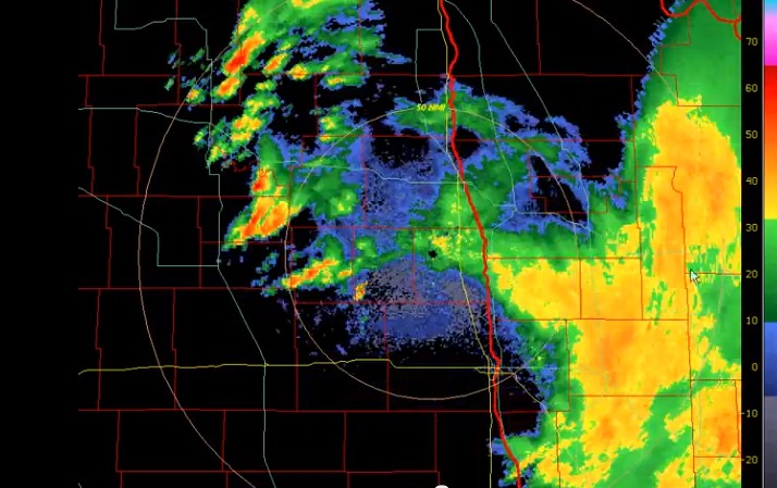
Instead of dealing with the real problem at hand, being how logging creates the perfect environment for fires to start (read more here), the Canadian government has been quietly relying on weather modification experiments, including cloud-seeding .... and in British Columbia, it's causing this :
And in Saskatchewan, it's causing this ....
Environment Canada is conducting simulated geo-engineering experiments to control climate change. Federal government documents received by former B.C. premier Bill Vander Zalm through a freedom of information request define geo-engineering as the modification of Earth systems. The document notes that geo-engineering methods are classified into two groups: solar radiation management, and carbon dioxide removal from the atmosphere. The briefing paper was prepared in advance of a top-level inter-agency meeting convened by Environment Canada to discuss matters about geo-engineering options to address climate change. (To see how this ties into the Bill Gates agenda, read this article here. ) Last summer, Vander Zalm requested information on climate-control engineering being done by the government. Many suspect that cloud-like streams left by airplanes are chemical trails, or “chemtrails” that contain unknown substances used to alter the weather. The former B.C. premier received 47 pages of documents from the federal government. Six pages were blank, and 10 pages had some portions blacked out. The retired politician said that the papers prove that Canada is into geo-engineering. “There’s no doubt about it,” Vander Zalm told the Straight by phone. “As to what extent and what they’re spending and where they’re doing it, we don’t know exactly.” (Straight News).
Some problems: One issue is where the rain would have fallen if you hadn't cloud seeded. Does a cloud seeding event in Alberta keep a farmer in Saskatchewan from getting rain that he or she might have received?" "So you're extracting moisture from the atmosphere. That's absolutely correct. However, these clouds would not precipitate in the area," said Friedrich. "They can evaporate and maybe they fall down as precipitation over the ocean [or another area]." (CBC)
Right now, there is a low pressure zone over Schuler, AB NEXRAD Tower. The low pressure system made its way from Pacific coast towards Spokane, WA tower; then steered south towards Boise, ID tower, then changed direction north towards Great Falls, MT tower; and now Schuler, AB tower! The system has been bringing much rain into southern Alberta and parts of Saskatchewan. Also see the following links:
Update: We have recent video footage here, depicting the sky of Upper Michigan that was also closely linked to this storm system. The resident who witnessed this, Jason Asselin, describes it as:
``All of a sudden it got very yellow outside, it felt strange and mysterious. Then it slowly looked very orange, it was the craziest thing I have ever witnessed over my head.``
Skies in Upper Michigan on the evening of July 22
A storm system stretching from Nebraska, to Iowa and Wisconsin has been analysed, and it appears that this storm is being largely shaped by NEXRAD stations working in conjunction with each other. The cloud plumes appear to be originating from power plants along the Nebraska and Iowa border. Please see our playlist, which clearly depicts the KOAX and KDMX NEXRAD stations involved in generating tapered linear storm systems.
Fig 1: Top image is a satellite portrayal of this storm system with its linear arm stretching into the Northern States and Canada. The bottom image is a satellite showing the current water vapour during this time. Watch the video here.
Fig 2: Moisture being bridged from KOAX to KDMX NEXRAD stations on July 23 at 01:15 UTC. This is shown in more detail using the radar stations (Fig 5) below.
Fig 3: The left image is KOAX Nexrad Station (radar) - Omaha, NE - July 23, 01.14 UTC.
The right image is KDMX Nexrad Station (radar) - Des Moines, IA - July 23, 01.15 UTC.
This is also consistent with the satellite image in Fig 2 above.
Click the photo above to enlarge. The Walter Scott Jr Energy Coal Plant runs at a maximum capacity of 1635 megawatts (MW), Fort Calhoun Nuclear Power at 478 MW, and North Omaha Coal Plant at 626 MW. Learn more here, and see relevant research paper.
Fig 4: Radar image showing moisture content of the storm system that we are interested in. Take note of how this storm system is tapered towards active NEXRAD stations, and is connected through numerous radar stations. The images that follow below will portray this in more detail. The stations from left to right are KUEX, KOAX, KDMX, KARX (top), KDVN (bottom), and KMKX. Watch the video here.
Fig 5: NEXRAD stations in the U.S. The red dots represent those that we are interested in analysing. Use this figure to correlate with the radar images that follow.
Fig 6: Grand Island/Hastings, NE (KUEX) NEXRAD Station. This is consistent with Fig 4.
Fig 7: Omaha, NE (KOAX) NEXRAD Station. This is consistent with Fig 4.
Fig 8: Des Moines, IA (KDMX) NEXRAD Station. This is consistent with Fig 4.
Fig 9: Davenport, IA (KDVN) NEXRAD Station. This is consistent with Fig 4.
Fig 10 La Crosse, WI (KARX). This is consistent with Fig 4.
Fig 11: Milwaukee, WI (KMKX) NEXRAD Station. This is consistent with Fig 4.
More investigation is needed with these radar anomalies and their apparent influence on storm systems and moisture-driven forces. Provided below is a list of useful tools for capturing these type of events. It is important to become familiar with these software tools. We recommend adding them to your bookmarks:
Firstly, we are surprised that none of the major media outlets have mentioned that the heavy rainfall southern Alberta received in the past two days originated from southern Montana, as seen in satellite imagery below. Prior to the escalated water levels in Alberta, similarly, Montana was also facing severe flooding. The Weather Network explains how the flood developed here, without mentioning a single word about Montana. The media merely tells part of the story, while it continues to be misinformed about the true nature of this storm, as reported by Globe & Mail:
Days of rain coupled with the spring run-off from the Rockies combined to bloat rivers in Alberta, and the flooding is expected to continue over the weekend. The South Saskatchewan River Valley is expected to peak late Sunday afternoon, Mr. Griffiths told reporters.
With the help of satellite images, we are lead to believe that this storm was generated using artificial precipitation methods, which are described in this video. We strongly recommend reading this post discussing weather patents that are being used to control storms and their relation to plume-shaped cloud systems. It is important to understand the weather modification patents that have lead up to this day. It is also crucial that we understand how aerosol emissions from power plants can affect cloud formations and precipitation generated in neighbouring areas, which has been found in recent studies. A great video which discusses this topic can be viewed here. This is not the first time that power plants have caused a freak storm of this nature.
This article will describe how the recent weather pattern formed, which brought majority of the recent flooding of rain into Alberta, accompanied by videos of weather data and NEXRAD animation. A playlist of all events can be viewed here. Part II discusses mainly Calgary and surrounding areas in southern Alberta, strictly using the Pacific and Prairie radar stations' data. Part II can be read here.
Regarding the satellite video below, pay close attention to the storm originating in southern Montana which moves north west into southern Alberta. At about 11 seconds in, we see a tapering arm stretching south to the Wyoming-Idaho border, which later feeds the southern end of the storm for some time. This storm system moves east to join other storms that originate in North and South Dakota. Also, pay attention around these areas of North and South Dakota, to see how storm systems suddenly emerge from central points.
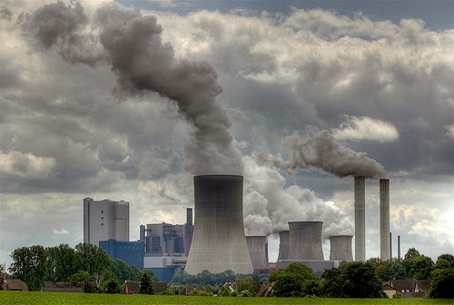
It is important to note how some of these storm systems are tapered , originating from a central point. Some of these central points are shown to be near NEXRAD (Doppler) sites and power plants. NEXRAD towers are capable of emitting electromagnetic waves at different frequencies that can affect weather patterns or particles in the atmosphere. With microwave transmitter capabilities, able of emitting over 700,000 watts in each pulse, these Doppler devices can generate an enormous amount of corona ions (charged particles) which bind to water molecules. The generation of CCN (cloud condensation nuclei) using frequency or electric charge is the corona-effect for ion generation of rain, which can be read about here. More importantly, there are power plants located in Billings and Colstrip, MT, which are capable of producing massive amounts of CCN, which can form into rain clouds and disrupt precipitation patterns. It is important to be aware of these types of artificial anthropogenic precipitation methods, as we believe this may be related to how the cloud system in Montana started.
What is interesting about where some of these storm systems are developing is that they are in close proximity to NEXRAD stations and / or power plants. Below is a snapshot of where the south Montana storm originates, which is near the KBLX NEXRAD station and J.E. Corette Power Plant near Billings, MT:
Environment Canada Satellite Image: Southern Alberta storm originates from south Montana
Above: NEXRAD Station (KBLX) near Billings, MT. Coincidence?
Above: Cloud plumes appearing on NEXRAD radar, suddenly being generated near active power plants, such as the ones found near Billings and Colstrip, MT. Click the photo to enlarge.
The storm system that appears in southern Montana also happens to be near the J.E. Corette Energy Plant. Located along the Yellowstone River on the outskirts of Billings, MT, the J.E. Corette plant is a coal-fired unit owned by PPL Montana, and it has a generating capacity of 153 megawatts. Roughly a hundred miles east is another power plant in Colstrip, MT, capable of producing over 2,000 MW of energy. Recently, in March of 2013, a lawsuit was filed against the Colstrip power plant, over pollution controls. There are numerous studies suggesting a strong correlation between air pollution and its impact on climate. The amount of CCN (cloud condensation nuclei) these types of power plants can produce is astounding, resulting in abundant clouds being generated and possibly heavy precipitation in downwind areas. An important study conducted on the impact of fossil fuel burning from power plants on our climate can be read here. The study suggests that:
The consequences of this technology for aerosol emissions, and in particular the regional scale impact on cloud micro-physics, have not been studied until now. We performed airborne investigations to measure aerosol size distributions in the air masses downwind of coal-fired power installations. We show how the current generation of clean technology reduces the emission of sulphur and fine particulate matter, but leads to an unanticipated increase in the direct emission of ultra-fine particles (1–10 nm median diameter) which are highly effective precursors of cloud condensation nuclei (CCN). Our analysis shows how these additional ultra-fine particles probably modify cloud micro-physics, as well as precipitation intensity and distribution on a regional scale downwind of emission sources. Effectively, the number of small water droplets might be increased, thus reducing the water available for large droplets and rain formation. The possible corresponding changes in the precipitation budget with a shift from more frequent steady rain to occasionally more vigorous rain events, or even a significant regional reduction of annual precipitation, introduce an unanticipated risk for regional climate and agricultural production, especially in semi-arid climate zones.
Above: The J.E. Corette Power Plant near Billings, MT
Regarding this clean technology, which creates finer particles in power plant emissions, and the fact that the Alberta flood occurred on June 2013, it is quite ironic, especially considering the Colstrip power plant's proposed plans for 2013, which state:
To increase particulate control to meet the MATS Rule, a wet electrostatic precipitator (Wet ESP) is added in series with each scrubber (pg. J-16) . . . Proposed changes to Section 316(b) issued under the Act will apply to power plants as well as other industrial facilities. They require facilities to utilize “best technology available.” The EPA expects to finalize power plant standards by June 2013 (pg. J-12).
As an example of illustrating anthropogenic clouds generated by means of aerosol emissions (CCN) in Calgary, Alberta, the ENMAX Calgary Energy Centre is a great example. Found on the north east corner edge of Stoney Trail, relying on fossil fuels and the burning natural gas (methane), this power plant is capable of forming enormous amounts of clouds in our sky. Acquired by ENMAX Energy through a subsidiary in 2008, this facility is a 320 megawatt natural gas-fuelled plant. A list of all plants can be found here.
Above: ENMAX Calgary Energy Centre found on the north east corner edge of Stoney Trail (Calgary, AB), generating an abundance of clouds from aerosol emissions. A list of generating stations for Alberta can be found here.
Above: Caught on radar, the Beaver Valley Nuclear Plant in Pennsylvania causes a freak snowstorm in Allegheny and Beaver counties, on Jan, 2013. Read more here.
At about 6 seconds into the video, you will notice that the storm system is generated in southern Montana, but more importantly, aerosol plumes from near active power plants can be seen feeding this storm. Some of this phenomenon can be viewed from NEXRAD KBLX radar in Billings, MT. The storm is further driven north by either wind patterns or active NEXRAD / Doppler electromagnetism, possibly using stations in southern Alberta. Later throughout the video, this storm passes east through other NEXRAD-active regions in neighbouring states. Overall, we can see this storm suddenly originating from specific points of interest, initially starting near Billings, Montana, being fed by active power plants, such as the one found in Colstrip, MT. This is what brought majority of the rainfall in the past day, which caused severe flooding for Southern Alberta.
At about 10 seconds into the video, we see numerous other storms suddenly appearing at central points, specifically in North Dakota. These storms later merge with the one that was generated in south Montana. We have uploaded the various NEXRAD animations for these different stations to better depict what was occurring in those areas. You will see the storm systems being fed from specific areas as shown on radar, with possible electromagnetic activity being emitted from these radar stations, which can influence nearby cloud patterns and atmospheric particles. Tracking aerosol plume emissions from power plants using radar is difficult in some cases, due to the dynamics of cloud micro-physics and formations, but it can be seen in some cases.
NEXRAD animation screenshot: Grand Forks, North Dakota - NEXRAD Station (KMVX) for June 20 - 21. Notice where this storm system is tapering from--precisely where the Doppler station is located.
Map of NEXRAD Stations in the United States: White dots represent active NEXRAD stations, and red dots are those of interest to us, specifically in N/S Dakota and Nebraska.
Photograph of the KMVX NEXRAD station in North Dakota
Above: Is it a coincidence that the North Dakota Rain Project runs annually from June 1 - Aug 31?
With the amount of metallic and non-metallic particles in aerosols that are being sprayed (Geoengineering) in the upper atmosphere daily, which actively collect moisture to form / dissipate clouds, there should be no surprise at how some of these weather patterns are being driven. It is worth noting what Dane Wigington and other experts have to say on this topic. When clouds become laced with metallic particles, these clouds can then be influenced by electromagnetic waves emitted through NEXRAD radar or weather modification satellites. The air acts as a fluid, in which these particles are distributed. This is creating an ongoing problem in many areas and is spoken about here.
After watching the NEXRAD animations, one should be convinced that this is not how natural cloud systems are formed. We can clearly see the weather patterns and cloud formations being affected by electromagnetic waves (ie. radar) emitted from these NEXRAD stations. We have also seen many of the cloud formations to be fed from nearby power plants.
More research is needed in this field, and there needs to be a thorough investigation from officials around various States and Canadian cities for the amount of damage that has been caused in the name of weather modification and anthropogenic climate impacts. Let us not forget what happened during the Vietnam War in the 1960s, and the extent to which weather modification technology has advanced since then. There are also those who will purchase weather at the expense of others.
For possible motives regarding this flood, we have a post dedicated to this discussion. Part II can be read here, which takes a closer look at the radar stations near southern Alberta (and Calgary).
Intellicast Image: June 21st. Active aerosol-spraying continues off the West Coast of U.S. and Canada, which clearly act to intensify active weather systems that are being formed and moving inland.
Above: NEXRAD being documented by user Atlantic Skywatch
Artificial precipitation generation caught in north and south Dakota, feeding this large weather system stretching across the continent from West to Eastern Canada. This weather system has been flooding many areas, causing evacuation and much damage.
We are getting lots of rain in southern Alberta, causing some major flooding. Meanwhile, our government, or whatever they are endorsing in commercial jet fuel, has been actively spraying aerosols off the West Coast. Here is a photo from Intellicast satellite image below, which is merely one example. One can clearly see the "line" in the aerosols that were deployed. These aerosols collect moisture as they move inland, strengthening the oncoming weather front to be able to produce more desired rain or cloud cover.
It is quite interesting in noting the size of this weather front, stretching across the entire continent, from West to East. It is also bringing rain into some states in the U.S.
This is a similar image (below) provided by Environment Canada. As usual, they have censored out portions of the satellite (dark region), hiding aerosols or weather modification patterns in clouds that they do not want the public to see.


 Environment Canada is conducting simulated geo-engineering experiments to control climate change. Federal government documents received by former B.C. premier Bill Vander Zalm through a freedom of information request define geo-engineering as the modification of Earth systems. The document notes that geo-engineering methods are classified into two groups: solar radiation management, and carbon dioxide removal from the atmosphere. The briefing paper was prepared in advance of a top-level inter-agency meeting convened by Environment Canada to discuss matters about geo-engineering options to address climate change. (To see how this ties into the Bill Gates agenda, read this article here. ) Last summer, Vander Zalm requested information on climate-control engineering being done by the government. Many suspect that cloud-like streams left by airplanes are chemical trails, or “chemtrails” that contain unknown substances used to alter the weather. The former B.C. premier received 47 pages of documents from the federal government. Six pages were blank, and 10 pages had some portions blacked out. The retired politician said that the papers prove that Canada is into geo-engineering. “There’s no doubt about it,” Vander Zalm told the Straight by phone. “As to what extent and what they’re spending and where they’re doing it, we don’t know exactly.” (Straight News).


.jpg)
.png)


+-+1.15.gif)
+-+1.15.gif)