Right now, there is a low pressure zone over Schuler, AB NEXRAD Tower. The low pressure system made its way from Pacific coast towards Spokane, WA tower; then steered south towards Boise, ID tower, then changed direction north towards Great Falls, MT tower; and now Schuler, AB tower! The system has been bringing much rain into southern Alberta and parts of Saskatchewan. Also see the following links:
Many areas in southern Alberta are still recovering from the intense flooding that took place in late June, displacing many thousands of residents. There have been numerous other EM-induced storms in July that have been causing flash flooding and intense hail damage in many areas. We will present information as to the recent rain and cloud system we received in southern Alberta on July 7th and 8th. There has been no mention in the weather media of the tapering aerosol cloudplumes originating in the North-western States, which brought majority of the rain to southern Alberta. We will present evidence as to how these cloud systems have been generated precisely near the NEXRAD / Doppler stations using electromagnetic waves, and thereafter pushed into southern Alberta, bringing more rain to the flood-ravaged area. The NEXRAD stations which are of interest to us with regards to originating the cloud plumes are located near Portland, OR; Spokane, WA; and Boise, ID. A playlist for the events and weather data of July 7th can be seen here, and a playlist for July8th can be viewed here.
NEXRAD-induced cloud systems: We can clearly see three significant cloud plumes originating from NEXRAD stations in the U.S. The first plume (red) is from the NEXRAD station in Portland, OR. The last plumes (red and magenta) are originating from the NEXRAD stations in Spokane, WA and Boise, ID, respectively. We also noted a small plume originating from what appears to be a NEXRAD station in Medford, OR, and from the video, it appears to be pushed towards the Boise, ID station.
After watching the above satellite animation for July 7th - 8th, we can clearly see a tapered cloud plume originating near Portland, OR and later feeding into southern Alberta. A one hour loop from Intellicast satellite animation shows this plume in more detail. What is interesting about this plume is that it appears to be heavy aerosol sprayed off the West coast of Washington / Oregon, if not mistaken for the similar-looking cirrus clouds . However, after watching sky time lapse videos for areas near the coast, we can see that these appear to be aerosols advancing through the sky here and here. In Happy Valley, OR, this video was also captured, which shows the moisture-collected aerosols that have the signature of strong electromagnetic pulsation, causing the linear shape of this metallic-laced aerosol plume. This was also confirmed by residents living in these areas, as well as video footage here and here.
The NEXRAD animation data for Portland, OR during the time which this aerosol plume was influenced can be viewed here. After watching this video, we can clearly see the NEXRAD station initially with very quiet activity, and then suddenly pulsing at this time, which we believe may be the electromagnetic attraction of the aerosol plume. The station then shortly ceases this EM-pulsing in all directions, and sends out what appears to be an electromagnetically-charged beam in the north east direction. Immediately thereafter, we can see the plume begin to originate just as was seen on the satellite animation, oriented in the same north east direction.
We can see that the plume driven from the Portland NEXRAD station is not only moving east, according to the natural wind flow pattern, but it is also moving north , which is not consistent with the wind patterns at that time.After viewing the animated data for wind movement in this area, we must ask ourselves what is driving this plume north if it is not electromagnetic forces emitted precisely from these NEXRAD stations? Although we believe that NEXRAD works alongside with wind, there are some experts suggesting that our wind patterns are being changed due to heavy Geoengineering operations. However, in this situation we see natural winds moving slightly east and south, not north.
July 7th: Calgary skies prior to the storm system arriving the next day
The Alberta skies time lapse during July 7th can be viewed for Calgary, AB here, and for Didsbury, AB here. Pictures for July 7th of Calgary skies can be viewed here. What appeared to be high altitude clouds (or aerosols) oriented south East-West advanced into Calgary prior to the storm system arriving the following day. An electromagnetic signature can be seen in the photo pictured left, showing the NEXRAD / Doppler effect in some of these high altitude clouds. This cloud system appears to be linked to north-west Montana, and some sky time lapse videos for Montana (NW) can be viewed here and here. The clouds in those areas of Montana's sky also appeared to be slightly pulsed.
Plumes created from NEXRAD stations near Spokane, WA
and Boise, ID, bringing more rain into southern Alberta
Later throughout the satellite animation, we see two more plumes created at NEXRAD stations near Spokane, WA and Boise, ID on July 8th. Cloud plume generation for the Spokane NEXRAD station can be viewed here, and the NEXRAD data for Boise, ID can be viewed here. During this time was when southern Alberta received most of its rain for this day. A time lapse video for Calgary, AB shows the heavily-pulsed aerosol cloud system arriving from Washington and Idaho state prior to the rainfall. Doppler radar animation for July 8th in Calgary, AB can be viewed here. We believe this storm system was further pushed north-east into southern Alberta with the help of nearby Doppler stations in Canada. Additionally, we have noted an intense electromagnetic blastat 5:20 and 6:20 pm (MDT) from the Doppler station located near Vernon, BC, which we believe caused the north-east advancing storm to be pushed further east. We also find it interesting that in the morning of July 8th, we see a small storm system initially just West of High River, AB later being pushed directly through the centre of the Strathmore Doppler station here.
We will add more material as it comes along from other residents in the area. If you have any information, photos, or videos, please email: weatherpeace@gmail.com
Calgary, AB: July 8th - Electromagnetic pulsing seen throughout the NEXRAD-blanketed skies
Calgary, AB: Evening of July 8th - After the receding storm, NEXRAD leaves its linear plume marks in the sky
Calgary, AB: The evening sky displaying its electromagnetic signature throughout the clouds
Calgary, AB: The sky facing north, showing this NEXRAD-induced linear front in the clouds
If this storm was intentional, there is much speculation for reasons why this would be done. From our recent article, we learned that this storm was the result of man-made rainfall, which was generated by heavy power plant aerosol emissions in Montana. Interestingly, the Colstrip power plant in Montana was sued over pollution controls back in March of 2013. Alberta also has its share of problems regarding coal plants. Prior to the escalated water levels in Calgary, AB, Montana was similarly facing floods.
It is interesting that India has also suffered major flooding around the same time. Some possible political reasons are stated by Alfred Lambremont Webre in his article. We do not see any organization benefiting from this catastrophe except for large corporations and banks. This is taking into consideration the amount of homes that must be re-built, and packaged products that were purchased for nearly 80,000 flood victims. This would largely include packaged food and beverage companies also. Some readers have suggested the Red Crossbeing an organization benefiting from this event. Other individuals have suggested that this event is a cover-up (distraction) from other crucially-important events happening at the time, such as the recent Alberta oil spill prior to the flood, gun confiscation, or perhaps worldwide events such as the Syrian war and Egypt / Brazil protests. Another possible reason may be Canada (and Alberta in this case) wanting to sell its oil to China instead of U.S., as America is their largest purchaser. First Nation communities have been hit hard with this flood, and prior to this, their leaders have been standing firmly against expanding new oil sands operations on Native territory. Insurance companies have not to worry, as this type of incident is not covered under their policy. Houses along the riverside that were once worth a fortune have now had their market prices decrease significantly.
As reported by media outlets, this flood followed some 36 hours of unusually heavy rainfall - some communities receiving six months of their normal rainfall in under two days. It is strange indeed, as we have shown. We think that this will be blamed on "global warming" without mentioning a single word on Geoengineering (weather modification) or high-altitude aerosol spraying. We are unsure if this may lead to more carbon taxing of citizens.
However, what we do find interesting is that this recent rain storm system (as was shown) originated from Montana, which along with many other states, has been experiencing severe forest fires recently. We saw that this storm system was intensified and pushed east into North Dakota and Minnesota. Recently, these same areas have been experiencing worsening forest fires. We do not have sufficient evidence as of now, but could the manufacturing of these storms serve as a way of preventing these forest fires, without informing the public? Or could this be a far greater agenda? It is simply a matter of speculation for now.
Part I can be read here, which discusses how the storm originated in Montana using artificial precipitation methods, with viewable data from NEXRAD radar. Here is a loop playback of the prairie Doppler radar stations, showing that the storm system is actively being driven up north, as seen from various Doppler stations, into southern Alberta where the flooding worsened. We can see that this storm system is clearly coming up from Montana. The Pacific view of the Doppler stations can be seen here. The full playlist of all videos can be seen here.
If you are not familiar with NEXRAD technology or power plant aerosol emissionsand their impact on climate, please watch this video. When viewing the radar animations, the electromagnetic activity emitted from these large Doppler radar sites and its influence on atmospheric particles (i.e. clouds) needs to be thoroughly investigated. These Doppler stations in southern Alberta appear to be working in conjunction with those (NEXRAD) in Montana. Each central point is a Doppler (NEXRAD) station, which emits electromagnetic waves (over 700,000 watts of microwave energy in each pulse) that may steer / intensify / weaken nearby storm systems, sometimes preceded by high altitude aerosol spraying. The military has numerous patents, which use electromagnetic technology that can influence storm systems significantly.
This storm system was steered north, originating from south Montana, possibly using NEXRAD / Doppler stations. Read more about Doppler stations near Calgary here. Their influence on these storm systems can clearly be seen when one observes different sets of radar animation data. Here is a video of potential Doppler electromagnetism moving the storm system from west to east on June 20th.
Here are photos of how the Calgary sky looked after the clouds parted and heavy rainfall desisted, taken in order throughout the day. Another set can be found here. Many signs of the Doppler / NEXRAD effect can be seen in these photos. With signs of aerosol deployed throughout the sky, and NEXRAD (Doppler radar) influence on metallic-laced clouds, this may be the aftermath of a geoengineered storm. Here is a playlist of all unusual weather phenomenon (video footage) linked to this event. There is a video filmed by a resident on June 18th, regarding an unusual cloud formation which is pictured below. Read more about roll clouds being generated at Doppler radar stations here.
Calgary, AB - June 18: Unusual cloud formations have been reported by residents from southern Alberta, which seems to correlate well with what has been described regarding the geoengineering of this storm system.
Satellite / Radar images: Why is the mainstream media not discussing the large amount of rainfall that originated in Montana, where NEXRAD / Doppler radar stations possibly steering the storm north west into southern Alberta?
Photograph of the Doppler Radar Station (CXSM), which is north of Strathmore. Map can be found here.
Heavy aerosol spraying in Montana, days prior to the intense flooding. Once the skies are laced with metallic oxides which mix with new-forming cloud systems, these weather systems can be controlled through the use of EM waves emitted from Doppler stations.
Weather Station in Calgary equipped with numerous satellite equipment. Why is this facility not labelled on Google maps?
Storm Aftermath in Calgary, AB: Remnants of heavy aerosol spray left in the sky the evening of June 21st. These trails are laced with metallic nano-particles, and the Doppler effect can be seen pulsating through them. All photos can be seen here and another set here.
Photograph from a resident: This photo was taken flying over Calgary as the storm progresses on June 20th. What was seen and described by a local were several black jets coming into Calgary above the storm, spraying heavy aerosols. Take note of the NEXRAD-induced ripples that are formed once the sky is pulsed with EM waves, after being laced with these metallic aerosols.
Calgary, AB: NEXRAD-Doppler effect can be seen throughout the sky, affecting these cloud patterns
Calgary, AB: Freshly sprayed aerosols (Chemtrail) swiftly disperse in the sky
Firstly, we are surprised that none of the major media outlets have mentioned that the heavy rainfall southern Alberta received in the past two days originated from southern Montana, as seen in satellite imagery below. Prior to the escalated water levels in Alberta, similarly, Montana was also facing severe flooding. The Weather Network explains how the flood developed here, without mentioning a single word about Montana. The media merely tells part of the story, while it continues to be misinformed about the true nature of this storm, as reported by Globe & Mail:
Days of rain coupled with the spring run-off from the Rockies combined to bloat rivers in Alberta, and the flooding is expected to continue over the weekend. The South Saskatchewan River Valley is expected to peak late Sunday afternoon, Mr. Griffiths told reporters.
With the help of satellite images, we are lead to believe that this storm was generated using artificial precipitation methods, which are described in this video. We strongly recommend reading this post discussing weather patents that are being used to control storms and their relation to plume-shaped cloud systems. It is important to understand the weather modification patents that have lead up to this day. It is also crucial that we understand how aerosol emissions from power plants can affect cloud formations and precipitation generated in neighbouring areas, which has been found in recent studies. A great video which discusses this topic can be viewed here. This is not the first time that power plants have caused a freak storm of this nature.
This article will describe how the recent weather pattern formed, which brought majority of the recent flooding of rain into Alberta, accompanied by videos of weather data and NEXRAD animation. A playlist of all events can be viewed here. Part II discusses mainly Calgary and surrounding areas in southern Alberta, strictly using the Pacific and Prairie radar stations' data. Part II can be read here.
Regarding the satellite video below, pay close attention to the storm originating in southern Montana which moves north west into southern Alberta. At about 11 seconds in, we see a tapering arm stretching south to the Wyoming-Idaho border, which later feeds the southern end of the storm for some time. This storm system moves east to join other storms that originate in North and South Dakota. Also, pay attention around these areas of North and South Dakota, to see how storm systems suddenly emerge from central points.
It is important to note how some of these storm systems are tapered , originating from a central point. Some of these central points are shown to be near NEXRAD (Doppler) sites and power plants. NEXRAD towers are capable of emitting electromagnetic waves at different frequencies that can affect weather patterns or particles in the atmosphere. With microwave transmitter capabilities, able of emitting over 700,000 watts in each pulse, these Doppler devices can generate an enormous amount of corona ions (charged particles) which bind to water molecules. The generation of CCN (cloud condensation nuclei) using frequency or electric charge is the corona-effect for ion generation of rain, which can be read about here. More importantly, there are power plants located in Billings and Colstrip, MT, which are capable of producing massive amounts of CCN, which can form into rain clouds and disrupt precipitation patterns. It is important to be aware of these types of artificial anthropogenic precipitation methods, as we believe this may be related to how the cloud system in Montana started.
What is interesting about where some of these storm systems are developing is that they are in close proximity to NEXRAD stations and / or power plants. Below is a snapshot of where the south Montana storm originates, which is near the KBLX NEXRAD station and J.E. Corette Power Plant near Billings, MT:
Environment Canada Satellite Image: Southern Alberta storm originates from south Montana
Above: NEXRAD Station (KBLX) near Billings, MT. Coincidence?
Above: Cloud plumes appearing on NEXRAD radar, suddenly being generated near active power plants, such as the ones found near Billings and Colstrip, MT. Click the photo to enlarge.
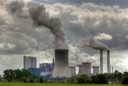
The storm system that appears in southern Montana also happens to be near the J.E. Corette Energy Plant. Located along the Yellowstone River on the outskirts of Billings, MT, the J.E. Corette plant is a coal-fired unit owned by PPL Montana, and it has a generating capacity of 153 megawatts. Roughly a hundred miles east is another power plant in Colstrip, MT, capable of producing over 2,000 MW of energy. Recently, in March of 2013, a lawsuit was filed against the Colstrip power plant, over pollution controls. There are numerous studies suggesting a strong correlation between air pollution and its impact on climate. The amount of CCN (cloud condensation nuclei) these types of power plants can produce is astounding, resulting in abundant clouds being generated and possibly heavy precipitation in downwind areas. An important study conducted on the impact of fossil fuel burning from power plants on our climate can be read here. The study suggests that:
The consequences of this technology for aerosol emissions, and in particular the regional scale impact on cloud micro-physics, have not been studied until now. We performed airborne investigations to measure aerosol size distributions in the air masses downwind of coal-fired power installations. We show how the current generation of clean technology reduces the emission of sulphur and fine particulate matter, but leads to an unanticipated increase in the direct emission of ultra-fine particles (1–10 nm median diameter) which are highly effective precursors of cloud condensation nuclei (CCN). Our analysis shows how these additional ultra-fine particles probably modify cloud micro-physics, as well as precipitation intensity and distribution on a regional scale downwind of emission sources. Effectively, the number of small water droplets might be increased, thus reducing the water available for large droplets and rain formation. The possible corresponding changes in the precipitation budget with a shift from more frequent steady rain to occasionally more vigorous rain events, or even a significant regional reduction of annual precipitation, introduce an unanticipated risk for regional climate and agricultural production, especially in semi-arid climate zones.
Above: The J.E. Corette Power Plant near Billings, MT
Regarding this clean technology, which creates finer particles in power plant emissions, and the fact that the Alberta flood occurred on June 2013, it is quite ironic, especially considering the Colstrip power plant's proposed plans for 2013, which state:
To increase particulate control to meet the MATS Rule, a wet electrostatic precipitator (Wet ESP) is added in series with each scrubber (pg. J-16) . . . Proposed changes to Section 316(b) issued under the Act will apply to power plants as well as other industrial facilities. They require facilities to utilize “best technology available.” The EPA expects to finalize power plant standards by June 2013 (pg. J-12).
As an example of illustrating anthropogenic clouds generated by means of aerosol emissions (CCN) in Calgary, Alberta, the ENMAX Calgary Energy Centre is a great example. Found on the north east corner edge of Stoney Trail, relying on fossil fuels and the burning natural gas (methane), this power plant is capable of forming enormous amounts of clouds in our sky. Acquired by ENMAX Energy through a subsidiary in 2008, this facility is a 320 megawatt natural gas-fuelled plant. A list of all plants can be found here.
Above: ENMAX Calgary Energy Centre found on the north east corner edge of Stoney Trail (Calgary, AB), generating an abundance of clouds from aerosol emissions. A list of generating stations for Alberta can be found here.
Above: Caught on radar, the Beaver Valley Nuclear Plant in Pennsylvania causes a freak snowstorm in Allegheny and Beaver counties, on Jan, 2013. Read more here.
At about 6 seconds into the video, you will notice that the storm system is generated in southern Montana, but more importantly, aerosol plumes from near active power plants can be seen feeding this storm. Some of this phenomenon can be viewed from NEXRAD KBLX radar in Billings, MT. The storm is further driven north by either wind patterns or active NEXRAD / Doppler electromagnetism, possibly using stations in southern Alberta. Later throughout the video, this storm passes east through other NEXRAD-active regions in neighbouring states. Overall, we can see this storm suddenly originating from specific points of interest, initially starting near Billings, Montana, being fed by active power plants, such as the one found in Colstrip, MT. This is what brought majority of the rainfall in the past day, which caused severe flooding for Southern Alberta.
At about 10 seconds into the video, we see numerous other storms suddenly appearing at central points, specifically in North Dakota. These storms later merge with the one that was generated in south Montana. We have uploaded the various NEXRAD animations for these different stations to better depict what was occurring in those areas. You will see the storm systems being fed from specific areas as shown on radar, with possible electromagnetic activity being emitted from these radar stations, which can influence nearby cloud patterns and atmospheric particles. Tracking aerosol plume emissions from power plants using radar is difficult in some cases, due to the dynamics of cloud micro-physics and formations, but it can be seen in some cases.
NEXRAD animation screenshot: Grand Forks, North Dakota - NEXRAD Station (KMVX) for June 20 - 21. Notice where this storm system is tapering from--precisely where the Doppler station is located.
Map of NEXRAD Stations in the United States: White dots represent active NEXRAD stations, and red dots are those of interest to us, specifically in N/S Dakota and Nebraska.
Photograph of the KMVX NEXRAD station in North Dakota
Above: Is it a coincidence that the North Dakota Rain Project runs annually from June 1 - Aug 31?
With the amount of metallic and non-metallic particles in aerosols that are being sprayed (Geoengineering) in the upper atmosphere daily, which actively collect moisture to form / dissipate clouds, there should be no surprise at how some of these weather patterns are being driven. It is worth noting what Dane Wigington and other experts have to say on this topic. When clouds become laced with metallic particles, these clouds can then be influenced by electromagnetic waves emitted through NEXRAD radar or weather modification satellites. The air acts as a fluid, in which these particles are distributed. This is creating an ongoing problem in many areas and is spoken about here.
After watching the NEXRAD animations, one should be convinced that this is not how natural cloud systems are formed. We can clearly see the weather patterns and cloud formations being affected by electromagnetic waves (ie. radar) emitted from these NEXRAD stations. We have also seen many of the cloud formations to be fed from nearby power plants.
More research is needed in this field, and there needs to be a thorough investigation from officials around various States and Canadian cities for the amount of damage that has been caused in the name of weather modification and anthropogenic climate impacts. Let us not forget what happened during the Vietnam War in the 1960s, and the extent to which weather modification technology has advanced since then. There are also those who will purchase weather at the expense of others.
For possible motives regarding this flood, we have a post dedicated to this discussion. Part II can be read here, which takes a closer look at the radar stations near southern Alberta (and Calgary).
Intellicast Image: June 21st. Active aerosol-spraying continues off the West Coast of U.S. and Canada, which clearly act to intensify active weather systems that are being formed and moving inland.
Above: NEXRAD being documented by user Atlantic Skywatch


.jpg)
.png)


 If this storm was intentional, there is much speculation for reasons why this would be done. From our recent article, we learned that this storm was the result of man-made rainfall, which was generated by heavy power plant aerosol emissions in Montana. Interestingly, the Colstrip power plant in Montana was sued over pollution controls back in March of 2013. Alberta also has its share of problems regarding coal plants. Prior to the escalated water levels in Calgary, AB, Montana was similarly facing floods.
 As reported by media outlets, this flood followed some 36 hours of unusually heavy rainfall - some communities receiving six months of their normal rainfall in under two days. It is strange indeed, as we have shown. We think that this will be blamed on "global warming" without mentioning a single word on Geoengineering (weather modification) or high-altitude aerosol spraying. We are unsure if this may lead to more carbon taxing of citizens.


+in+Calgary+-+not+showing+in+map.jpg)


 At about 10 seconds into the video, we see numerous other storms suddenly appearing at central points, specifically in North Dakota. These storms later merge with the one that was generated in south Montana. We have uploaded the various NEXRAD animations for these different stations to better depict what was occurring in those areas. You will see the storm systems being fed from specific areas as shown on radar, with possible electromagnetic activity being emitted from these radar stations, which can influence nearby cloud patterns and atmospheric particles. Tracking aerosol plume emissions from power plants using radar is difficult in some cases, due to the dynamics of cloud micro-physics and formations, but it can be seen in some cases.
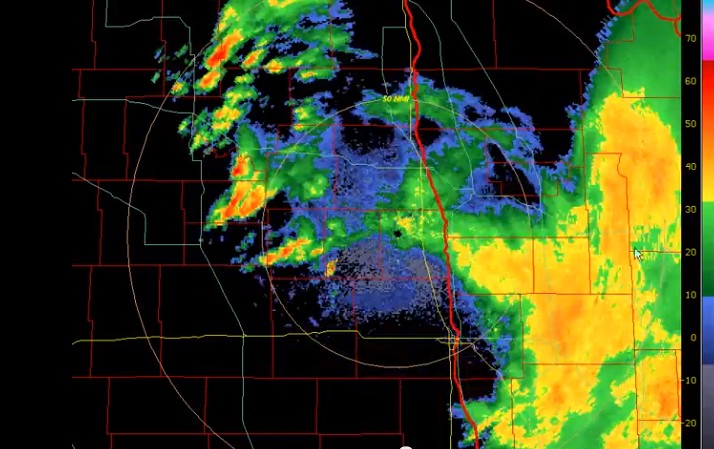


 With the amount of metallic and non-metallic particles in aerosols that are being sprayed (Geoengineering) in the upper atmosphere daily, which actively collect moisture to form / dissipate clouds, there should be no surprise at how some of these weather patterns are being driven. It is worth noting what Dane Wigington and other experts have to say on this topic. When clouds become laced with metallic particles, these clouds can then be influenced by electromagnetic waves emitted through NEXRAD radar or weather modification satellites. The air acts as a fluid, in which these particles are distributed. This is creating an ongoing problem in many areas and is spoken about here.