Today, Calgary residents witnessed a morning sky whose incoming clouds were filled with Doppler ripples and signs of electromagnetic signature. A time lapse of our sky can be viewed here. A map of all sky time lapse videos can be viewed here, in which Washington and Oregon state can be accessed on the right side of that page.
We have tracked this cloud system originating precisely from NEXRAD stations in Washington and Oregon, and have documented its movement using radar and satellite animation. The full playlist of all events can be seen here. In the satellite animation, pay close attention to where the tapering plume-shaped clouds originate from in Oregon and Washington, only to be later pushed into Alberta using Canadian Doppler Stations.
Above: Photos depicting Calgary's sky on July 17, roughly 11:00 am, facing East. Notice the linear arms of this storm system that are similar to the pulsing anomalies we see in radar viewed from Doppler stations. We believe that the Doppler stations are helping to move these clouds, and as a result shapes them with electromagnetic signatures.
We can clearly see clouds being generated as plumes in Oregon and Washington NEXRAD Stations, which are then driven north east into British Columbia, with the help of Canada's Doppler stations co-operating to bring this cloud system into Alberta. Most of the moisture and clouds are being driven north east from the Spokane, WA Station towards the Vernon Doppler station to end up in Alberta and eventually Calgary.
Above: The left image shows specific NEXRAD Stations in the U.S. that are of particular interest to us, because they are involved in generating the strange plume-shaped clouds that are pushed north into Canada. The right image shows the Canadian Doppler stations working in conjunction to further drive this moisture north into British Columbia and eventually Alberta.
Above: Satellite image of Western Canada on July 16, 19:30 UTC. Pay attention to the tapering plume
generated near Medford, OR on the bottom left.
Above: Medford, OR NEXRAD Radar: Tapering plume generated precisely from the Medford, OR (KMAX) Station
Above: Western Canada satellite image for July 17, 5:00 UTC. Pay close attention to the plume-shaped clouds generated at Portland, OR (left) and Pendleton, OR (right).
Above: Portland, OR (KRTX) NEXRAD Station on July 17, 5:02 UTC, generating a tapered
cloud system that was seen on satellite images.
Above: Pendleton, OR (KPDT) NEXRAD Station on July 17, 5:03 UTC, seen generating a tapering
plume-shaped cloud system as seen on satellite images.
Above: Western Canada satellite image for July 17, 17:30 UTC. Pay attention to the plume-shaped cloud
system originating near Spokane, WA.
Above: Spokane, WA (KOTX) NEXRAD Station on July 17, 17:44 UTC, seen
generating a tapered plume-shaped cloud system.
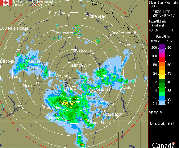
Above: Vernon, BC (Silver Star Mountain) Doppler Station receiving the cloud system that originated in Washington, and driving this system towards the Calgary Doppler Station. The time is July 17, 16:30 UTC.
Above: Strathmore, AB (near Calgary) Doppler station receiving the cloud system from British Columbia (Vernon Doppler Station), that originated from Washington. The timing is July 17, 16:30 UTC (10:30 a.m. MDT).
Above: Calgary's sky, facing north. We see the electromagnetic ripples as signs that a Doppler station has left its mark on these clouds. This is the signature of electromagnetic-induced clouds. All morning photos can be viewed here.
Aerosols seen stretching across north-west WA and Okanagan BC, pointing NE towards Edmonton, AB
Prior to an intense Edmonton storm (July 10), our team of Skywatchers have discovered an aerosol plume stretching nearly a thousand miles, across the Pacific and British Columbia. We believe that this was a heavy aerosol-spraying operation. The developing aerosols can be seen here. Closer detail of the aerosol movement can be seen with Intellicast here. A sky time lapse of this aerosol system going over Washington can be seen here and here. What is interesting about this aerosol system is its enormous length and the timing of Doppler / NEXRAD stations becoming very active during this time, further driving in the moisture-collected aerosol clouds to desired areas. Furthermore, these aerosols appear to be related to a weather system that developed near Edmonton and other nearby areas during that time. Take note of how a storm develops at the tip of this aerosol plume extending into Alberta near Edmonton.
During the time which these aerosols were moving across parts of Washington and Oregon, we see very active NEXRAD-pulsing and electromagnetic (EM) activity in Portland, OR, and especially Seattle, WA NEXRAD stations. Interestingly Langley Hill, WA NEXRAD station had its data conveniently missing during this time.
Approximate orientation of the aerosol plume, lining up with active NEXRAD stations (the yellow pins)
These aerosols that stretched across British Columbia conveniently line up with active NEXRAD / Doppler stations, pointing directly towards the Doppler station in Edmonton, AB. In Naramata, BC, we can see the aerosols appearing in the sky (above the cumulus clouds), and the clouds seem to be moving along the same orientation as the plume, while the aerosols actively collect moisture. We believe the aerosols not only to be influenced by NEXRAD / Doppler EM activity, but also gaining help from the wind pattern for July 10.
Aerosol plume collecting moisture, passing through the Pacific region, towards the Kelowna Doppler region, and directed towards Edmonton, AB
In watching where the moisture appears to be travelling, the Doppler stations for the Pacific region can be viewed here. Interestingly, Victoria's Doppler station has missing data during this time in which we see the Prairie Doppler stations (and Edmonton) pulsing intensely. Noting that the data is conveniently missing for the Victoria station (and Langley Hill, WA), during the time which the aerosol plume forms near Victoria, it makes us wonder if moisture is actively being fed from the coast. We see moisture / clouds being fed into Edmonton, AB through the Grand Prairie Doppler station (mostly) and the Kelowna Doppler station. Edmonton Doppler animation can be viewed here. The cloud system coming from Grand Prairie appears to have originated from the Prince George Doppler station that attracted moisture from the east. The cloud system arriving into Edmonton from the Kelowna Doppler station can be viewed here. In that video, we can clearly see moisture / clouds being driven north east directly towards Edmonton, AB.
Edmonton, AB: The high altitude aerosols seen on July 10th seems to be filled with electromagnetic signature prior to the storm
We can see the Edmonton Doppler station appears to be very active during the time which the storm rolls in from the north west, and clouds coming in from the south west. Furthermore, we see the storm heads directly east, and a linear feature can be seen driven south-east. The storm system appears to have been influenced by the Edmonton Doppler station.
The most recent Prairie radar data can be seen here, and during this time (July 10, 22:00 MDT) we see Saskatoon and Regina Doppler stations pulsing intensely, which can also be seen here (July 11, 04:00 MDT). The National Radar for these events can be seen here. After taking a
closer look at the Saskatoon Doppler station, we initially see a quiet radar, and afterwards we see intense electromagnetic activity pick up, which appears to be charging a storm system south east of the Doppler centre. This occurs again later in a similar fashion. The cloud system south east of the radar centre appears to be actively affected by EM waves emitted from the Doppler station. This type of storm generation can also be seen near the Regina Doppler station, which also appears to be super-charging a storm in the south east quadrant during the same time. Afterwards, we see strong EM activity north east of the Doppler station, later sending out energy to the south-west and north-west, while continuing to send out energy towards the north-east.
On the left image, we see moisture lined up to the south east of the radar centre. On the right image, we were able to portray these EM lines going out from the centre of the radar through the linear portions of the storm. Could electromagnetic waves emitted from the centre of the Doppler station explain this strange phenomenon we are seeing?
We must ask ourselves what is causing these mysterious storms to appear around the circumference of the Doppler stations? We also note the wind patterns for Saskatchewan during this time (July 11) is north. Furthermore, we must also take into consideration the weather system moving north-east, originating from the States into Montana and the lower Prairies. Keeping in mind that the wind is moving north, what is causing these storms on the radar to have this lineation oriented towards the centre of the radar if it is not electromagnetically-induced weather?
Edmonton, AB: The wicked storm that was shown advancing on the Doppler radar. The linear features of EM cloud influence seem to correlate well with what we saw on the Doppler radar.
Edmonton, AB: Rotating clouds seen by one resident on July 10th
Edmonton, AB: Storm photographed by a resident and photo-enhanced , showing the strange EM-induced shape
One resident showing the size of hail dropped in some areas of Edmonton, AB
Edmonton, AB: Photograph of strange-shaped hail, appearing to be somewhat flattened
Ootischenia, BC: A last glimpse of the aerosols seen passing through the Kootenay Valley on their way towards Alberta on July 11. Paused at this satellite image, note the fork of aerosols -- one path seen going through the Kootenay Valley, and another path going through the Okanagan Valley.
Windfield, BC: Aerosols seen passing through the Okanagan Valley on July 11th on their way to Alberta
Above: Photos taken by a local resident near Portland, OR, showing these aerosols stretching across the sky on July 11, at 6:45 am (PDT). In the first photo, the left shot is looking towards Mt. Hood (south), and the right shot is facing West. In the second photo, the top shot is again looking towards Mt. Hood (south) and the bottom shot is looking up the Hood River Valley.
Here is the weather satellite animation data for Western Canada, regarding the storms developing in southern Alberta. The playback is July 3 - 6.00 am to July 4 - 11.00 pm MST. Take note of where the strange tapering plumes (storms) are developing in S.Alberta. We are uncertain of where the source of this cloud formation is being fed from.
On July 4th, Calgary residents and others in southern Alberta were issued a tornado warning from Environment Canada. What was not mentioned to the public was the censoring of our weather data.
During this animation playback above, take note of the screen blackout which occurs on July 3 immediately after 20:30 UTC. We are astonished at the amount of data that was taken out of this loop. There is a large segment missing between July 3, 20:30 and July 4, 6:00 UTC. These frames have been removed from the satellite images. We believe this data has been intentionally censored out, prior to the developing severe storm in southern Alberta. Several Doppler stations in Western Canada also had their data removed during this time, prior to heavy electromagnetic pulsing coming from the NEXRAD / Doppler stations in the Prairies region. We also checked the data for Eastern Canada, and noted similarly this censoring to the public in selected areas. Furthermore, we also noted that July 4, 19:30 - 20:30 UTC (1:30 - 2:30 pm MST) has been censored out.
Several Doppler stations in Western Canada have had their data censored from the public. Prior to almost all stations appearing blank, note the strong EM-pulsation at the Prairie stations, such as Calgary, Medicine Hat and others.
We have provided several Doppler animations for review of the developing storms in southern Alberta here. From the detailed video, we can see that the storm initially begins near Wetaskiwin, AB, in which we are uncertain of where exactly all this moisture is coming from. The Doppler station (centred at Strathmore, AB) becomes very active in what appears to be generation of plasma clouds shortly afterwards, driving the growing storm system south. This can be seen better by looking at the plasma clouds generated around the Doppler station that have become concentrated, pointing towards the storm system. During this time, the sky in parts of Calgary went from blue to a thin blanket of white. This can be further analysed in our weather time lapse video. In that video, pay close attention to the artificial ionospheric plasma clouds produced by nearby Doppler stations that can generate electromagnetic waves in the same frequency range as HAARP. These EM-induced clouds can be seen driven by EM frequency (from Doppler station) from right to left in the video. Then shortly afterwards, we see the developing storm system is driven in from left to right, advancing in the opposite direction.
At this point, it becomes more clear to see the straight-edged cloud system that has formed, using EM frequencies emitted from the Doppler station. This is further manifested when one takes a close look at the thin and bent linear arm that is pulsed in the same direction. During this time, further strange anomalies can be seen near Lake Louis, which is pictured below:
Doppler station at Strathmore, AB: Note the strange linear arm (at centre) being driven south along with the storm system, towards the Doppler centre using electromagnetic frequencies. Another strange anomaly can be seen near Lake Louis (left), as three bent linear arms of clouds have become stretched, mimicking the circumference of the radar.
Once the west arm of the storm system has reached the centre of the Doppler station, and after EM pulsation from the Doppler station has appeared to cease, the storm system stops going south and resumes its natural motion east. Meanwhile, there are other numerous storm systems developing south of Calgary, during the video playback.
Video footage of the storm making its way into northern Calgary (6:30 pm) can be seen here. Note how the southern end of the storm is well defined by its linear (radar-pulsed) edge. This also seems to be consistent with the radar at this time. The storm system appeared to be moving very fast, despite the apparent wind speed. Very low clouds were also spotted separately moving below this system.
We noted that the cloud system near the Rockies seems to appear quiet in the beginning of the video, however, as soon as the Doppler station becomes active in pulsing, one can see stretched cloud
systems being driven north east directly towards the Doppler station centre. Furthermore, note the strange cloud system forming near Hanna, AB here. It appears to hold very little moisture, and has no apparent source for its cloud development.
There may be more strange anomalies and other natural formations not discussed in the length of this entry. Please notify us if you come across anything interesting.
Red Deer, AB: This is a photograph sent in by one of our Skywatchers, facing north as the storm system passed over this town. It is interesting to note the shape of these clouds, which are referred to by meteorologists as mammatus clouds. However, one must consider how these clouds form in response to artificial radiative heating from EM waves emitted by ground or air-based devices.
Calgary, AB: NEXRAD-pulsed clouds prior to the storm
Calgary, AB: On-lookers stand in astonishment, viewing the intensity of this strange storm
North-east in Calgary, AB: In this photograph, an unusually low, long tapering cloud appears to be moving from left to right, immediately above the houses
Could this be the linear bent arm we saw being driven south in the radar?
Another photograph showing the intensity of this oncoming storm


.gif)

.gif)
.gif)

.gif)