Today, Calgary residents
witnessed a morning sky whose incoming clouds were filled with
Doppler ripples and signs of electromagnetic signature. A time lapse of our sky can be viewed
here. A map of all sky time lapse videos can be viewed
here, in which Washington and Oregon state can be accessed on the right side of that page.
We have tracked this cloud system originating precisely from
NEXRAD stations in Washington and Oregon, and have documented its movement using radar and satellite animation. The full playlist of all events can be seen
here. In the
satellite animation, pay close attention to where the tapering plume-shaped clouds originate from in Oregon and Washington, only to be later pushed into Alberta using
Canadian Doppler Stations.
 |
Above: Photos depicting Calgary's sky on July 17, roughly 11:00 am, facing East. Notice the linear arms of this storm system that are similar to the pulsing anomalies we see in radar viewed from Doppler stations. We believe that the Doppler stations are helping to move these clouds, and as a result shapes them with electromagnetic signatures.
|
We can clearly
see clouds being generated as plumes in
Oregon and
Washington NEXRAD Stations, which are then driven north east into British Columbia, with the help of Canada's
Doppler stations co-operating to bring this cloud system into Alberta. Most of the moisture and clouds are being driven north east from the
Spokane, WA Station towards the
Vernon Doppler station to end up in
Alberta and eventually Calgary.
Above: The left image shows specific NEXRAD Stations in the U.S. that are of particular interest to us, because they are involved in generating the strange plume-shaped clouds that are pushed north into Canada. The right image shows the Canadian Doppler stations working in conjunction to further drive this moisture north into British Columbia and eventually Alberta.
 |
Above: Satellite image of Western Canada on July 16, 19:30 UTC. Pay attention to the tapering plume
generated near Medford, OR on the bottom left. |
.gif) |
| Above: Medford, OR NEXRAD Radar: Tapering plume generated precisely from the Medford, OR (KMAX) Station |
 |
| Above: Western Canada satellite image for July 17, 5:00 UTC. Pay close attention to the plume-shaped clouds generated at Portland, OR (left) and Pendleton, OR (right). |
.gif) |
Above: Portland, OR (KRTX) NEXRAD Station on July 17, 5:02 UTC, generating a tapered
cloud system that was seen on satellite images. |
.gif) |
Above: Pendleton, OR (KPDT) NEXRAD Station on July 17, 5:03 UTC, seen generating a tapering
plume-shaped cloud system as seen on satellite images. |
 |
Above: Western Canada satellite image for July 17, 17:30 UTC. Pay attention to the plume-shaped cloud
system originating near Spokane, WA. |
.gif) |
Above: Spokane, WA (KOTX) NEXRAD Station on July 17, 17:44 UTC, seen
generating a tapered plume-shaped cloud system. |
 |
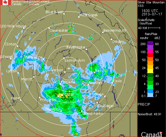
| Above: Vernon, BC (Silver Star Mountain) Doppler Station receiving the cloud system that originated in Washington, and driving this system towards the Calgary Doppler Station. The time is July 17, 16:30 UTC. |
 |
| Above: Strathmore, AB (near Calgary) Doppler station receiving the cloud system from British Columbia (Vernon Doppler Station), that originated from Washington. The timing is July 17, 16:30 UTC (10:30 a.m. MDT). |
 |
| Above: Calgary's sky, facing north. We see the electromagnetic ripples as signs that a Doppler station has left its mark on these clouds. This is the signature of electromagnetic-induced clouds. All morning photos can be viewed here. |


.gif)

.gif)
.gif)

.gif)


I saw the ripples in the Calgary sky too this morning and I expected what happened later in the afternoon. I shared these findings with others today again.
ReplyDeleteExcellent work here again. Thank you.